
Weather is not only influenced by the Sun, but also by
Sunlight (and sometimes moonlight) interacting with raindrops makes Rainbows, such as shown in this photo by Bob Fay:
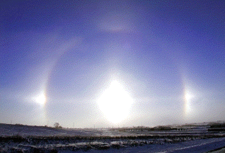
Sunlight interacting with atmospheric ice crystals makes Sun Dogs, such as shown in this photo taken on 21 December 2000 by Jeff Storjohann of the Carroll (Iowa) Daily Times Herald and sent to me by Elmer Schettler:
According to Goddard Press Release No. 00-50 dated 9 May 2000,
According to the latest spacecraft and ocean buoy observations, the La Nina has disappeared entirely in the eastern Pacific Ocean and is rapidly disappearing over the rest of the Pacific. "The current lack of cold water support below the surface means that this La Nina will have a difficult time sustaining itself for much longer", according to David Adamec, a research oceanographer at Goddard Space Flight Center in Greenbelt, Md. "As expected, the La Nina reached a maximum in intensity during January 2000 and has been waning ever since." The spacecraft data have also shown that since March, La Nina's cold surface water is being replaced by water that is now 4 degrees Fahrenheit warmer than normal off the coast of South America. The current longevity of this "warm water patch" is now beginning to affect the atmosphere by weakening the trade winds there. These weakened winds are also very unfavorable for the persistence of La Nina conditions. ... Anomalous behavior of the tropical Pacific Ocean has been affecting weather patterns in the U.S. for the past three years. During the spring of 1997 ... the strongest El Nino ... Suddenly during May of 1998, the warm waters of El Nino were replaced by the cold water phenomenon known as La Nina which has persisted till now. ...".
However, according to ENSO Diagonistic Advisory 2000/5 issued May 10, 2000, "... The large-scale oceanic and atmospheric circulation patterns
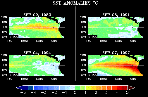
conditions in the tropical Pacific during April. Consistent cold episode-related oceanic features include: below normal SSTs (negative anomalies greater than -1�C) in the western and central Pacific (Fig. 1),
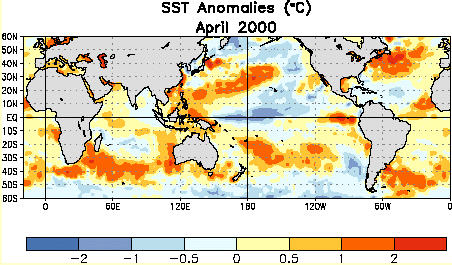
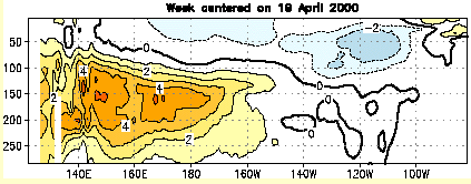
and above- (below-) normal subsurface temperatures in the western (eastern) equatorial Pacific (Fig. 2).
... Despite the persistence of many cold-episode related features, SST anomalies have been increasing during recent weeks ... This local warming of the SSTs is likely to be short-lived, as the large-scale subsurface thermal structure does not favor the development of a warm episode at this time. ... it is likely that cold episode conditions will gradually weaken over the next 6 months and that near-normal or slightly cooler than normal conditions will be present in the tropical Pacific at the end of the year. ...".
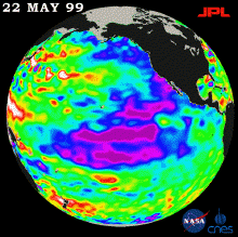
According to a 27 May 1999 web article on the JPL El Nino web pages: "... New sea surface height measurements from the TOPEX/Poseidon satellite show that the sea level and temperature of the entire Pacific is "out of balance," ... according to oceanographer Dr. William Patzert of JPL. "Our data certainly show that the unusual oceanic climatic conditions that gave rise to El Niño and La Niña are not returning to a normal state. ... Our planet's climate system continues to exhibit rather wild behavior.
These large warm and cold, high and low sea levels are slow-developing and long-lasting ... ". The unusually cool water (areas of lower sea level shown in blue and purple) extends from the Gulf of Alaska along the North American coast, sweeping south-westward from Baja California, where it merges with the remnants of La Niña. The La Niña phenomenon's cool, lower sea levels across the equator continue to weaken and break into (purple) patches. ... Areas where the Pacific Ocean is "normal" appear in green. ... In this image, the purple areas are about 18 centimeters (7 inches) below normal, creating a deficit in the heat supply to the surface waters. The white areas show the sea surface is between 14 and 32 centimeters (6 to 13 inches) above normal; in the red areas, it's about 10 centimeters (4 inches) above normal. For more information, please visit the TOPEX/Poseidon project web page ...".
according to the 8 June 1998 web page ScienceNOW, which states: "... Vice President Al Gore and scientists from the National Oceanic and Atmospheric Administration announced at a meeting here this morning that each of the first 5 months of the year "far exceed" previous global temperature records. Although El Nino has been waning in the last few weeks, scientists say the increase so far is large enough that 1998 is a very good bet to surpass 1997, the current record holder (Science, 16 January, page 315). ... A temperature increase itself is not a surprise: El Nino is defined by warming in the tropical Pacific, which typically fuels a rise in global temperatures a few months later. But this year's increase has been larger than expected. Based on measurements from weather stations, satellites, ocean ships, and buoys, NOAA researchers calculated that combined land and ocean temperatures are 0.25 degrees Celsius warmer than any previous recorded January-through-May period. Although 5 months is too brief to be meaningful on its own, climate researchers say that the jumps are well outside the 0.05 degree standard deviation on global averages. That should be enough to make this year the hottest of the millennium, says climatologist Philip Jones of the University of East Anglia in Norwich, England. Studies of tree rings and other indirect measures of temperature have suggested that the last decade has been the hottest in at least the last 600 years--and likely the hottest of the last 1000. With El Nino cooling off, he says, 1999 and 2000 should be slightly cooler. ..." However, I wonder whether El Nino will actually cool off that much.
CNN reports that, according to Ted Scambos of CU-Boulder and NOAA, a section about 40 kilometers long and five kilometers wide broke off the Larsen B Ice Shelf in February and March 1998. The rate of Antarctic warming is several times that of the global average and "The warming trend appears to be related to a reduction in sea ice. The question now is what is causing the reduction. At this point we do not have enough evidence to find a smoking gun." Since snow and ice reflect more sunlight than sea water, and sea water absorbs more sunlight than snow and ice, the more the ice melts the faster the warming trend.
Scherer, Aldahan, Tulaczyk, Engelhardt, and Kamb, in Science, 281 (3 July 1998) 82-85, report paleontologic and geochemical data derived from sediments recovered from beneath the West Antarctic ice sheet (WAIS) that imply that open marine conditions existed in the southern part of the Ross sector of West Antarctica during the late Pleistocene, and thus that the WAIS has at least partially collapsed at least once since the late Miocene. The WAIS is the world's only large ice sheet that is grounded well below sea level at its margins, making it susceptible to collapse. Collapse of the WAIS would result in a rise in eustatic sea level of 5 to 6 m. A sea level higher than at present during the penultimate interglacial [marine oxygen isotope stage 5e (MIS 5e)], 123,000 years ago (ka), has been cited as evidence of past WAIS collapse. The Southern Ocean was warmer than at present during certain late Quaternary intervals. Most notable of these warm periods, and the most likely candidate for the time of WAIS collapse, is MIS 11, which occurred about 400,000 years ago. This interglacial was of unusually long duration and was characterized by biogenic carbonate deposition in the high-latitude Southern Ocean and unusually deep southerly penetration of North Atlantic deep water. WAIS retreat during one or more earlier or subsequent interglacials, including MIS 5e, or collapse out of phase with the climate cycle cannot be ruled out. Given the remaining uncertainties regarding ice sheet mechanics and climatic forcing, it is not yet possible to predict the probability of WAIS collapse within the coming centuries.
The 1997 El Nino coincided with the volcanic eruption of Soufriere.
The 1982 El Nino coincided with the volcanic eruption of El Chicon.
According to C.Claiborne Ray's article in the New York Times of 28 April 1998, in 1993 the largest known cluster of volcanoes, covering an area the size of New York State was discovered. It is 600 miles northwest of Easter Island, and has 1,133 seamounts and volcanoes, far more than any other area then known on dry land or under the ocean. In 1995, scientists reported that a spate of undersea quakes and lava eruptions had preceded the onset of the El Nino cycle then in effect. Dr. Daniel A. Walker, a geophysicist at the University of Hawaii, said that the seismic activity was the most unusual it had been in 30 years and tentatively linked it to El Nino.
In January 2002, according to 18, 19, 21, and 24 January 2002 articles in the BBC: "...
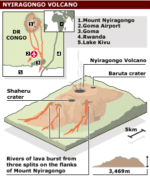
... Mount Nyiragongo in the Democratic Republic of Congo ... is located in part of the East African Rift Valley system ... [Here is a] ... Nasa satellite image
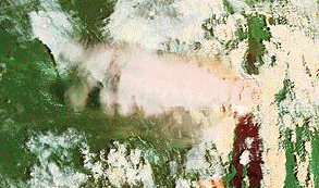
five hours after the [January 2002] eruption began ... as many as 650,000 people [have been] made homeless by the eruption of Mount Nyiragongo. A 50-metre wide stream of molten lava is still flowing through Goma, which lies 10 kilometres (six miles) from the volcano, destroying everything in its path and killing at least 45 people. ... Mount Nyiragongo ... was last active in 1994, when a lava lake reappeared in its summit crater ... The latest eruption is more serious. Lava from Nyiragongo can travel at 60 kilometres per hour and there are concerns that lava reaching a nearby lake could ... react with gas in the lake, with catastrophic consequences ... in 1986, Lake Nyos in Cameroon released a cloud of gas, which killed more than 1,700 people ...
... There are reports of a second volcano erupting in eastern Democratic Republic of Congo. The volcano on Mount Nyamuragira sent molten lava flowing into Virunga national park, but there are no reports of casualties. Since Nyiragongo erupted last week destroying much of Goma, powerful earth tremors have been aggravating relief work and have destroyed more than 1,500 houses and several schools just across the border in Rwanda. ... Seismologists have confirmed that some of the disturbances that have shaken the Goma area over the past week have registered up to five on the Richter scale and can be defined as small earthquakes. ... vulcanologists have warned that eruptions could spread along the Rift Valley which straddles Uganda, Kenya and Tanzania, where there are dormant volcanoes. ... recent studies had shown evidence of volcanic activity suggested a serious threat to the entire region. ... the volcanic eruptions in DR Congo could potentially stir magma lying some five to 10 kilometres below the Rift Valley surface in East Africa, where there are "volcanic activities". ... ".
In December 2000, according to 20 December 2000 articles in the BBC: "... a major eruption on the Popocatepetl volcano ...
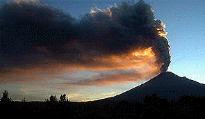
... located just 60 kilometres (37 miles) from Mexico City, sent showers of red-hot rocks hundreds of feet into the night sky in several huge explosions. ...". According to the Volcano World website, "... The 18 December [2000] eruption has been reported to be the largest eruption of Popocateptl in a thousand years. ...".
In March 2000, David Whitehouse wrote a BBC article describing steam rings
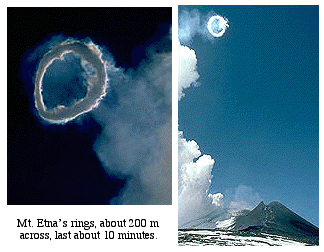
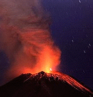
being blown by Mt. Etna. Mt. Etna had Strombolian explosions and lava flows in July 1997, and experienced a swarm of earthquakes on 10 January 1998. Two earthquakes shook Mt. Etna on July 22, 1998, causing increased activity at the volcano. Following these quakes, lava began to flow down Etna's slopes, and steam and ash rose six miles (~9.5 km) into the air. About a quarter of an inch of ash from this event fell on Catania's airport, forcing its closure late Wednesday. Some scientists believe this activity is a precursor to a larger future eruption of Etna. Activity has continued through October 11, 1998.
In February 2000, Mayon Volcano, Philippines, erupted, as shown in this image from the BBC:
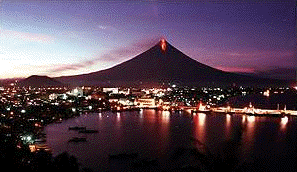
According to the Volcano World website, "... On 28 February, the Mayon Volcano had two powerful eruptions. ... The alert level has been raised to the maximum level of five. At least 30,000 people have fled the area. ... On 24 February, the Mayon Volcano erupted and sent superheated ash into the air. The ash rained as far as seven miles away.... The Philippine Institute of Volcanology and Seismology said fourteen explosions were recorded by late afternoon. The strongest sent ash 4 1/2 miles into the air and darkened the sky in some villages. ... Officials warned that a more violent explosion could occur at any time. ...".
On December 1, 1998, Popocatepetl erupted. An ash plume reached 6 miles (10 km) into the air. Authorities were preparing for the possible evacuation of villages within a 10 mile (16 km) radius of the volcano. Continued explosions could loosen snow on the top of Popocatepetl, causing avalanches and mudslides. Popocatepetl had its largest eruption since 1925 on 30 June 1997, sending ash 7.5 miles high.
On 21 September 1997 a huge lava dome of Soufriere on Montserrat collapsed and explosions from the volcano sent eruption columns to 40,000 feet. The lava dome collapse produced rivers of hot rock and gas (pyroclastic flows) which overran the island's airport and several villages on the eastern side of the island. Subsequent explosions of Soufriere, continuing into October 1997, sent ash clouds to heights of 20,000 to 25,000 feet (6,000-7,500 m). On 26 December 1997, a lava dome collapse . On 26 February 1998, Montserrat was in the path of a Total Solar Eclipse. On 3 July 1998, Montserrat erupted again, sending ash to an altitude of 45,000 feet.
Krakatau, which erupted violently in 1883, remains active in 1997.
Kiluaea continues to erupt lava flows.
The 1997-98 El Nino is the largest on record.
1991: Mount Pinatubo on the island of Luzon (15.0N, 120.0E) erupted catastrophically in June 1991 after over 600 years of inactivity. The Blizzard of 1993 occurred two years later. Global stratospheric aerosol mass from the eruption was monitored by SAGE II.
According to SAGE II: "...global aerosol mass reached a peak near 30 megatons after the Pinatubo eruption and started to decline (with an e-folding time of approximately 1 year) by mid-1992 as significant numbers of particles began to sediment into the troposphere. By mid-1993, global mass had fallen to about 12 megatons, which was the peak value observed following the 1982 eruption of the Mexican volcano El Chichon. Barring another major eruption, it [was] anticipated that the pre-Pinatubo level (less than 1 megaton) [would] be reached by late 1995 or early 1996." UCSB has some links to more web sites about the Pinatubo eruption.
1982: The El Chichon caldera was formed during the very explosive El Chichon eruptions of 1982, and is a few hundred meters deep by about a kilometer wide. 10 to 20 million tons of aerosols were put into the stratosphere. 1982 was also the year of a large El Nino.
1963: Agung erupted in 1963. 10 to 20 million tons of aerosols were put into the stratosphere.
1883: The eruption and collapse of the caldera of Krakatau in 1883 produced one of the largest explosions on Earth in recorded time (VEI=6) and destroyed much of Krakatau island, leaving only a remnant. 50 million tons of aerosols were put into the stratosphere.
1815: The 1815 eruption of Tambora was the largest explosive eruption in recent historic time. About 150 cubic kilometers of ash were erupted (about 150 times more than the 1980 eruption of Mount St. Helens). 200 million tons of aerosols were put into the stratosphere. The 1815 eruption of Tambora caused the "Year without a Summer". Daily minimum temperatures were abnormally low in the northern hemisphere from late spring to early autumn. Famine was widespread because of crop failures.
1783: In June 1783, Laki in Iceland began to erupt. There was initially a violent eruption with enormous lava fountains, followed by lava flows of fissure basalt lasting into 1784. About 12 cubic kilometers of magma came from this flow. Perhaps 100 million tons of aerosols were put into the stratosphere. 75 percent of the livestock of Iceland died, as did 24 percent of the people.
536: In March of 536, perhaps at Rabaul in Papua New Guinea, a huge eruption occurred whose effects were observed in China, the Middle East, and Europe. Perhaps 300 million tons of aerosols were put into the stratosphere. A severe plauge epidemic hit Africa, Europe and Asia from 541 to 544, killing 20 to 25 percent of the population.
1650 BC: The eruption of Santorini in Greece in 1,650 B.C. was one of the largest in the last 10,000 years. About 7 cubic miles (30 cubic km) of rhyodacite magma was erupted. The plinian column during the initial phase of the eruption was about 23 miles (36 km) high. The removal of such a large volume of magma caused the volcano to collapse, producing a caldera. Ash fell over a large area in the eastern Mediterranean and Turkey. The eruption probably caused the end of the Minoan civilization on the island of Crete.
71,000-74,000 years ago: Toba, in Sumatra, erupted explosively about 71,000 to 74,000 years ago. Perhaps 1,000 million tons of aerosols were put into the stratosphere. According to a Discover article:
"... Mount Toba in Sumatra blew 800 cubic kilometers of ash into the air--4,000 times as much as Mount St. Helens--the largest volcanic eruption in more than 400 million years. Toba buried most of India under ash and must have darkened skies over a third of the hemisphere for weeks. ... a six-year global volcanic winter ensued, caused by light-reflecting sulfur particles lingering in the atmosphere. Average summer temperatures dropped by 21 degrees at high latitudes, and 75 percent of the Northern Hemisphere's plants may have died. ... A thousand-year ice age began ... caused perhaps by an increasing amount of snow that failed to melt over the summer. This snow cover would have reflected more sunlight off Earth's surface, making the world still colder. The effect on humans, who had been enjoying a relatively warm period, must have been devastating. ... Perhaps only a few thousand people ... survived. ... Some anthropologists believe that ...[human]... genetic homogeneity is the result of a "population bottleneck"--that at some time in the past our ancestors went through an event that greatly reduced our numbers and thus our genetic variation. Based on estimates of mutation rates, Penn State geneticist Henry Harpending says the bottleneck happened sometime after ... 100,000 years ago and before a population increase ... around 50,000 years ago. ...".
120,000 years ago: According to an article by Tristan Marshall in the 7 October 2000 New Scientist: "... a volcano ... on El Hierro in the Canary Islands ... rising at least 1500 metres above sea level tore itself apart. A huge chunk of the north-west side of the island plunged onto the sea floor, breaking up as it fell. What remains behind is a bay 15 kilometres across, whose gently sloping floor is backed by a breathtaking semicircular escarpment more than a kilometre high. ... in 1997 evidence emerged of giant waves dating from around this time on the opposite side of the Atlantic--in the Bahamas. ... unusual boulders perched 20 metres above sea level on the island of Eleuthera in the Bahamas ... were huge--each weighing up to 2000 tonnes. They also rested directly on rocks that were much younger. How had the boulders got there? ... giant waves were the only plausible mechanism. ... Paul ... Hearty and ... Conrad Neumann ... also identified a series of chevron ridges up to 10 kilometres across on Eleuthera and neighbouring islands ... A tsunami between 40 and 50 metres high would account for both the transport of the boulders on Eleuthera and the chevron ridges ... Simon Day ... has discovered that a huge chunk of La Palma, the most volcanically active island in the Canaries, is now unstable. ...".
According to a 4 October 2000 article on the BBC website (from which the above image is taken): "... one flank of the Cumbre Vieja volcano on the island of La Palma, in the Canaries archipelago, is unstable and could plunge into the ocean. ... Swiss researchers who have modelled the landslide say half a trillion tonnes of rock falling into the water all at once would create a wave 650 metres high (2,130 feet) that would spread out and travel across the Atlantic ... It would have a wavelength of 30 to 40 kilometres (18 to 25 miles) travelling westwards across the Atlantic at speeds up to 720 km/h (450 mph) towards America. ... The wall of water would weaken as it crossed the ocean, but would still be 40-50 metres (130-160 feet) high by the time it hit land. The surge would create havoc in North America as much as 20 kilometres (12 miles) inland. ...".
600,000 years ago: "... At ... [the] youngest caldera, Lava Creek, ...[in]... Yellowstone in the US, 1000 cubic kilometres of ash and pumice spewed out 600,000 years ago ...".
1,300,000 years ago: "... The second great [Yellowstone] explosion formed the Island Park caldera 1.3 million years ago. This caldera ...[is]... the smallest of the three ...".
14 million years ago: The Roza basaltic flow erupted in the Columbia River Basalt Group 14 million years ago. About 700 cubic kilometers of magma came from this flow. Perhaps 6,000 million tons of aerosols were put into the stratosphere.
65 million years ago: The Deccan basaltic flow erupted in India about 65 million years ago. About 2,000 cubic kilometers of magma came from this flow. Since India was then south of its present position, the Deccan basalt traps of India were then antipodal to the Chicxulub impact on the Yucutan Peninsula.
200 million years ago: Pangaea began to be split up by massive lava flows in the Central Atlantic Magmatic Provice, which includes the Hudson River Palisades, the Amazon Basin, and parts of Spain and West Africa.
According to an AP article in The New York Times of 27 April 1999: "... The massive eruptions 200 million years ago tore apart the ancient continent of Pangea and may have caused a mass extinction of animals, the researchers reported in the current issue of the journal Science. Remnants of this event include the new Brazilian find as well as other formations in South America, West Africa, Spain and North America, among them the towering palisades along the Hudson River. The previously unrecognized area of ancient lava flow covers about 965,000 square miles in the Amazon basin. An analysis of the newly found rocks showed that the eruption occurred at the same time and had the same origin as lava flows found on the other continents, said Dr. Paul R. Renne of the University of California at Berkeley. A mass extinction at the same time seems to have been connected to the huge magma flow, he added. ... The great eruption, which occurred over a few million years, split apart Pangea, opening up what is now the Atlantic Ocean, the scientists said. The lava field it produced has been named the Central Atlantic Magmatic Province. With the addition of the Brazilian formation, it totals some 2.7 million square miles. ... The next-largest known lava flows are the Deccan Traps in India and the Siberian Traps, each just under half the size of the Central Atlantic lava field. ...".
250 million years ago: The Siberian Traps basaltic flow began about the time of a comet impact and the Permian-Triassic extinction, also around the time that the Siberian Plate collided with Laurentia (Europe and North America) forming the Ural Mountains.
500 to 250 million years ago, the Appalachian Mountains formed. Associated with the Appalachians was volcanic activity, including that at the Pivot Point of the Cartersville Fault.
References:
Understanding the Earth, ed. by Brown, Hawkesworth, and Wilson, Cambridge 1992.
The Historical Atlas of the Earth, by Stephen Jay Gould, Roger Osborne, and Donald Tarling, Henry Holt and Company 1996.
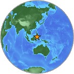
According to a USGS web page there was a "... Magnitude 8.9 ...[quake on the Full Moon of ]... Sunday, December 26, 2004 at 00:58:50 (UTC) ...
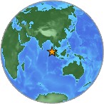
... OFF THE WEST COAST OF NORTHERN SUMATRA ... Many people killed by tsunamis in Sri Lanka and Thailand. Tsunamis also observed on the coasts of Maldives, Cocos Island and Sumatra. Felt widely in northern Sumatra. Also felt in Bangladesh, India, Malaysia, Myanmar, Singapore and Thailand. This is the fifth largest earthquake in the world since 1900 and is the largest since the 1964 Prince William Sound, Alaska earthquake. ...".
Although 2 days after the preceding New Moon of 12 December 2004 there was, according to a USGS web page, "... magnitude 6.8 event ...
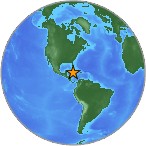
... in the CAYMAN ISLANDS REGION ...",
near the following New Moon of 10 January 2005 there was no large quake of Magnitude 7 or greater, despite the prediction of Jim Berkland's syzygyjob.org web page "... with 85% confidence, for the Super Seismic Window of January 08-15, 2005 ... Globally, ... one or more major quakes of 7.0-9.0M. ...", no such major quakes occurred. Instead of a single large quake antipodal to Sumatra, that time period had a two-loop pattern
 a
USGS web page]
a
USGS web page]of quakes of magnitude 5 to 7.
One day after the following Full Moon of 25 January 2005, according to a USGS web page, ".... A ... swarm ... of earthquakes ... recently occurred beneath the Andaman Sea east of the Nicobar Islands, starting 26 January 2005. The earthquake activity is in a broad sense part of the aftershock sequence associated with the great Sumatra-Andaman Islands earthquake of 26 December 2004 ... The swarm activity that began on 26 January nonetheless represents a dramatic burst of seismic activity within the aftershock sequence following the great 26 December main shock ...".
Near the second following New Moon of 8 February 2005 ( Chinese New Year of the Wood Chicken ), on 5 February 2005, according to a USGS web page, there was a "... The magnitude 7.1 event ...
... located in the CELEBES SEA. ...".
According to a USGS web page there was a "... Magnitude 4.9 ... earthquake ... Depth 15.0 kilometers ... Location ... 15 km (10 miles) NE of Fort Payne, Alabama ... 55 km (35 miles) NW of Rome, Georgia ... Tuesday, April 29, 2003 at 04:59:38 AM (EDT) ...[ 2 days before the New Moon of 1 May 2003. It shook my house in Cartersville, Georgia, and was the first earthquake I have ever experienced. ]... Cracked foundations and bricks fallen from chimneys were reported at Fort Payne. The water system at Valley Head also reported muddy water. ...[Prior to this earthquake, the]... largest recorded earthquake in this seismic zone ...[had been]... a magnitude 4.6 that occurred in 1973 near Knoxville. ... The Eastern Tennessee seismic zone, which extends from south west Virginia to north east Alabama ...
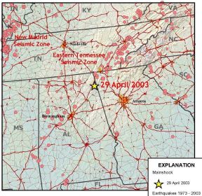
... is one of the most active earthquake areas in the Southeast. ...
...[ The following image, adapted from a USGS web page,
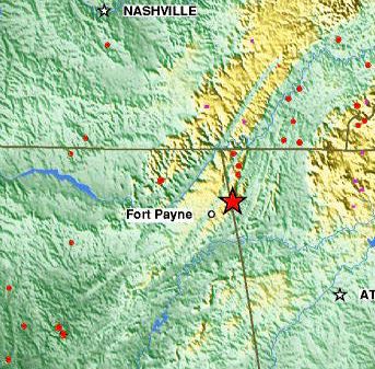
shows a thin green strip that bisects a larger yellow area that is the Cumberland Plateau and related plateau/mountain areas. Below Chattanooga, the Tennessee River flows through the thin green strip, which is a rift valley splitting the Cumberland Plateau from related high ground to the southeast. The little red dots are earthquakes since 1990 at depth 33 km or less. The little magenta dots are earthquakes since 1990 deeper than 33 km, and they tend to be in the Smoky Mountains, further east from the rift valley than the shallower earthquakes. Acording to a southeast Tennessee web page: "... Southeast Tennessee's Sequatchie Valley is one of the most unique valleys in the world. One of only two "rift valleys," the other being the Great Victoria Valley in Africa, [ I note that there may be more than those two - consider, for example, Iceland being rifted by the Mid-Atlantic Ridge. ] the Sequatchie Valley was formed by giant shears as the plateau literally split apart ...".]...
... Earthquakes in the central and eastern U.S., although less frequent, are typically felt over a much broader region than the western U.S. East of the Rockies, an earthquake can be felt in an area as much as ten times greater than a similar magnitude earthquake on the west coast. ... in the eastern Tennessee seismic zone the relation between faults and earthquakes is ... enigmatic. The Eastern U.S. is far from the plate boundaries, the nearest of which are in the center of the Atlantic Ocean and in the Caribbean Sea. No active faults are known to reach the surface in the region, although the area is laced with ancient faults that developed as the Appalachian Mountains formed several hundred million years ago. ...".
0316 GMT (0846 local time) 26 January 2001 (just after the end of the Year of the Metal Dragon), a 7.7 Earthquake hit India at the mouth of the (now mostly dry) Saraswati River. According to the BBC: "... Only about 18 quakes of this strength occur each year. It was a rare large quake in a region that is frequently shaken by smaller ones. The last comparable quake in the region occurred on 16 June, 1819, killing 2,000 people. That quake was estimated to be about magnitude 7.7 on the impulse scale, slightly less than the current quake. ... [ The current quake ] was a relatively shallow one that delivered much destructive energy to the surface. ... With more than 6,000 confirmed dead and authorities saying the figure could reach 20,000, rescue workers are mostly finding bodies under the piles of concrete and masonry. ...
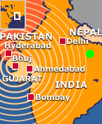
... Millions of Hindu pilgrims attending the Kumbh Mela festival in India's eastern state of Uttar Pradesh felt the ground sway beneath them, but there was no panic. ...". The Maha Kumbh Mela (held every 144 years) was held at the confluence of the Ganga, Yamuna, and Saraswati Rivers near Allahabad, India ( green dot on map ). The Saraswati River is now mostly dry, but until about 6,000 years ago it was a major part of the drainage system of the Indian subcontinent. Perhaps the 2001 Earthquake indicated that Garuda was still visiting the Saraswati (the region with principal god Indra) as well as the Ganges (the region with principal gods Shiva and Ganesha).
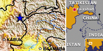
... The earthquake shook buildings in the Afghan capital, Kabul, where residents fled outdoors. Similar scenes were also reported in other cities in northern areas of Pakistan and India, where the tremors were felt. ...".
1747 GMT 20 September 1999 (near the end of Yom Kippur 5760), on 21 September 1999 local time, a 7.6 Earthquake hit Taiwan. According to the BBC: "... The earthquake which ... killed more than 1,000 people in central Taiwan ... was unusual ... Normally, quakes in the region occur hundreds of kilometres out to sea, far away from urban populations. But this tremor, which measured about 7.6 on the Richter scale, struck inland, close to the central city of Taichung.
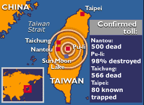
It was also very near the Earth's surface. ... "It looks as if this one was peculiar in some way," said Dr Chris Browitt from the British Geological Survey in Edinburgh. "It looks as like it was much shallower than usual and in a different area." This was confirmed by reporters on the ground. "This quake happened in the mountains on the western side of the island," said Diane Baker of the Taipei Times. "The big cities of Taipei and Taichung are unprotected for something like this." Recently history shows there have been earthquakes around magnitude 7.5 in the region more than once a decade for the last three decades. The last tremor on this scale to hit the island was on 14 November, 1986. But again, this occurred under the ocean and the resulting death toll was restricted to just 15. "You've got to remember that a magnitude 7.5 earthquake will occur maybe four times a year somewhere in the world. ..." Tremors can occur as deep as 700 km. As recently as 1993, Taiwan experienced a quake that was over 150 km down. But this latest quake was probably no more than a few kilometres below the surface. The destructive power of an earthquake comes from the momentum gathered when two opposing "faults" or plates of rock, which may have been locked together for decades, suddenly move apart. The result is that solid rock which normally moves only with the passing of geological ages accelerates briefly to 5,000mph, unleashing huge quantities of energy and creating a shaking movement of up to a metre a second. Taiwan sits is a very active seismological region where the relatively small Philippine plate is slowly grinding into the very large Eurasian plate. To the north of the island, the Philippine plate is being forced under the Eurasian plate mass - what seismologists call a subduction zone - whereas to the south, the opposite is happening. Of concern to local people will be the danger that comes from aftershocks, ... "Back in 1935 there was a magnitude 7.1 which killed over 3,000 people in the west of Taiwan and it had an aftershock about three months later which killed just under 3,000 people." ".
On Sunday, 26 September 1999, according to the BBC: "Taiwan suffered a major aftershock ... that killed at least three people and injured 58 others, destroyed buildings and roads already weakened from last week's devastating earthquake, and sent thousands of horrified residents scurrying for safety. The aftershock, which measured 6.8, hit at 7:52 a.m. and was centered about 6 miles east of Sun Moon Lake in Nantou county. This mountainous region in the middle of the island was the epicenter of last week's 7.6-magnitude quake, which killed more than 2,000 people. Local radio and television reports from Taiwan said the 10-second aftershock set off numerous landslides across the country. ... More than 100,000 people remain homeless, and many cities, including parts of the capital, are without electricity, as the earthquake and its aftershocks caused severe damage to power generating plants and substations.... More than 7,300 aftershocks have hit Taiwan since last Tuesday's earthquake, an average of almost one a minute. Eight of the jolts measured six or above and have been classified as major quakes in their own right. Officials of Taiwan's Seismology Center said they expected aftershocks to continue for several months and that further quakes of 6.8 magnitude are possible. Taiwan straddles a major fault line on the western edge of the Pacific "rim of fire" and has dozens of tremors each year. ...".
17 August 1999, 6 days after a Total Eclipse of the Sun, a 7.4 Earthquake hit Turkey (one of the NATO countries heavily involved in the Kosovo conflictct), killing tens of thousands of people. This image is from the BBC:
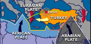
There were associated tsunamis. According to a Washington Post Foreign Service article by Lee Hockstader: "... BURSA, Turkey, Aug. 22&emdash;It was just past 3 a.m. last Tuesday [17 August 1999] when Yuksel Er shuffled from his bedroom to extinguish the bathroom light. ... Er -- who lives in Yalova, just south of Istanbul on the eastern shore of the Sea of Marmara -- ... had just come from the bathroom when the quake struck with a deafening roar that lasted 45 seconds. "It was awful," he said. "It was like a science fiction movie when a fireball rushes toward you and blows open your doors. I saw it coming clearly through the window in my son's room. It looked like a red fireball." ...".
17 July 1998, a 7.0 Earthquake hit near Papua New Guinea, creating 30-foot tsunamis that wiped out villages on the North Coast of Papua New Guinea. A page on the website www.cbjd.net said "... an OZ TV news item showed an Australian Geology Professor from PNG University interviewing survivors of the Tsunami. The survivor reported that as the sea wave swept in it was on fire--as was the air above it. ... Many bodies were apparently burnt. ..." and also quoted ABCNEWS.com as saying "... Particularly troubling was the question from a 15-year-old schoolgirl who asked about a "mountain of water with fire sparkles." Many of the victims had what appeared to be severe burns, suggesting that the water was on fire. ...".
According to a 23 April 2002 article by Kenneth Chang in The New York Times: "... A microphone in the Pacific Ocean near Wake Island recorded a 45-second, low-frequency roar, too low to be heard by human ears. ... Earthquakes can generate similar low rumbles, but those last only about 10 seconds ... It was the sound of nearly a cubic mile of sediment giving way along an ocean bottom slope 2,200 miles away off Papua New Guinea. ... an underwater landslide ... churned up the 30-foot-high tsunami
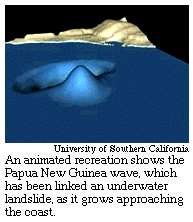
that crashed onto coastal villages of Papua New Guinea on July 17, 1998, killing more than 2,100 people. ... the earthquake had shaken loose a landslide that in turn caused the tsunami. Surveys of the ocean bottom found freshly collapsed sediment that slid nearly a mile down a 25-degree slope. ...".
10 January 1998, before the Chinese New Year, a 5.8 Earthquake hit Northeastern China, damaging part of the Great Wall.
8 November 1997 (Chinese year 4694), the year of Comet Hale-Bopp, a 7.9 Earthquake hit China about 700 km northwest of Lhasa, Tibet.
27 July 1976, the year of Comet West, an 8.0 Earthquake hit Tangshan, China. According to a page on the website www.cbjd.net, the "... June 5, 1977, New York Times described the great earthquake which destroyed Tangshan, China on July 28, 1976, and killed over 650,000 people. "Just before the first tremor at 3:42 am, the sky lit up like daylight. The multi-hued lights, mainly white and red, were seen up to 200 miles away. Leaves on many trees were burned to a crisp and growing vegetables were scorched on one side, as if by a fireball."".
According to a USGS web page: "... Prince William Sound, Alaska 1964 March 28 03:36:14 UTC (March 27 local), Magnitude 9.2 ... This great earthquake and ensuing tsunami took 125 lives (tsunami 110, earthquake 15) ... Anchorage, about 120 kilometers northwest of the epicenter, sustained the most severe damage to property. ... Duration of the shock was estimated at 3 minutes. ... The earthquake was accompanied by vertical displacement over an area of about 520,00 square kilometers. The major area of uplift trended northeast from southern Kodiak Island to Price William Sound and trended east-west to the east of the sound. Vertical displacements ranged from about 11.5 meters of uplift to 2.3 meters of subsidence relative to sea level. Off the southwest end of Montague Island, there was absolute vertical displacement of about 13 - 15 meters. ... This shock generated a tsunami that devasted many towns along the Gulf of Alaska, and left serious damage at Alberni and Port Alberni, Canada, along the West Coast of the United States (15 killed), and in Hawaii. The maximum wave height recorded was 67 meters at Valdez Inlet. Seiche action in rivers, lakes, bayous, and protected harbors and waterways along the Gulf Coast of Louisiana and Texas caused minor damage. It was also recorded on tide gages in Cuba and Puerto Rico. ...".
According to a USGS web page: the "... Largest Earthquakes in the World Since 1900 [were:] ...
They were the only ones since 1900 of magnitude 9.0 or greater. In comparison, the 1906 San Franciso earthquake was a 7.8, according to another USGS web page.
According to a USGS web page: "... 1886 September 01 02:51 UTC (local August 31), 7.3M, Intensity X ... the most damaging earthquake to occur in the Southeast United States and one of the largest historic shocks in Eastern North America. It damaged or destroyed many buildings in the old city of Charleston and killed 60 people. ... Many acres of ground were overflowed with sand, and craterlets as much as 6.4 meters across were formed. In a few locations, water from the craterlets spouted to heights of about 4.5 to 6 meters. Fissures 1 meter wide extended parallel to canal and stream banks. ... Structural damage was reported several hundred kilometers from Charleston (including central Alabama, central Ohio, eastern Kentucky, southern Virginia, and western West Virginia), and long-period effects were observed at distances exceeding 1,000 kilometers. ... This earthquake was reported from distant places such as Boston, Massachusetts; Milwaukee, Wisconsin, Chicago, Illinois; Cuba and Bermuda. ... Other intraplate earthquakes include those at Cape Ann, Massachusetts (1755), and New Madrid, Missouri (1811-1812). Earthquakes ... occurring within plates are not similarly understood. This problem still is being studied more than 100 years after the earthquake. ...".
According to a USGS web page: "... the Mississippi River valley earthquakes of 1811-1812 rank as some of the largest in the United States since its settlement by Europeans. The area of strong shaking associated with these shocks is two to three times larger than that of the 1964 Alaska earthquake and 10 times larger than that of the 1906 San Francisco earthquake. The magnitude of these series of earthquakes, usually named the New Madrid, Missiouri, earthquakes, vary considerably between the mb and Ms values estimated by Nuttli. ... The first and second earthquakes occurred in Arkansas (December 16, 1811 - two shocks - Mfa 7.2, MSn 8.5 and Mfa 7.0, MSn 8.0) and the third and fourth in Missouri (January 23, 1812, Mfa 7.1, MSn 8.4; and February 7, 1812, Mfa 7.4, MSn 8.8). Otto Nuttli, however, has postulated another strong earthquake in Arkansas on December 16 at 18:00 UTC (MSn 8.0). This would make a total of five earthquakes of magnitude MSn 8.0 or higher occurring in the period December 16, 1811 through February 7, 1812. ... A notable area of subsidence is Reelfoot Lake in Tennessee ... Subsidence there ranged from 1.5 to 6 meters, although larger amounts were reported. ...". According to another USGS web page: ".. Shortly after 2 o'clock on the morning of December 16, 1811, the Mississippi River valley was convulsed by an earthquake so severe that it awakened people in cities as distant at Pittsburgh, Pennsylvania, and Norfolk, Virginia. ... studies of the seismicity since 1812 show that the region is behaving in a manner more or less typical of active seismic zones. ... extrapolations of recurrence curves for the region indicate return periods -- depending on the investigator -- of anywhere between about 400 to 1,000 years for an earthquake the size of the December 16, 1811 event ...".
...