Some more about
According to the BBC on 1998 August 20, 13.5 million people have been evacuated from their homes and 5.5 million people have been made homeless. Flood waters on both the Yangtze and Han Rivers are putting what state television called special pressure on embankments close to the city of Wuhan. A flood crest on the Songhua River is expected to surge through Harbin on Friday 1998 August 21, adding to water levels already at an all time high. Harbin is at the edge of the river. It has a population of about nine million and is home to some of China's biggest industrial concerns.
According to CNN, the floods are the worst in 50 years in China's northeast provinces, and floods along central China's Yangtze River are already the worst since 1954, when more than 30,000 people were killed. In 1998, over 2,000 people have lost their lives. News coverage in China has included China Daily's story of the hero who became a human sandbag, telling how Wang Zhangcheng, a physically disabled man in his 60s, used his body to block a 3-foot hole in a levee in Wuhan, and China television's story of Xu Hongping baring her breasts to squirt milk onto hornet stings of PLA soldiers fighting China's worst flooding since 1954, showing the maternal bond between ordinary Chinese and the army. "The soldiers have come to protect us," Xu told the TV crew. "What I did was nothing."
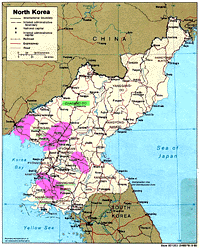
According to CNN "... August 19, 1998 ... Two million North Koreans -- nearly 10 percent of the population -- may have died during three years of famine in North Korea ... To survive the persisting food shortages, North Koreans are eating weeds, grasses and corn stalks that are mashed into powder and sometimes mixed with flour to make noodles or cakes. Over the past three years, the famine has killed an estimated 300,000 to 800,000 people annually, with the number of deaths peaking in 1997 ... Deaths were most likely from famine-related illnesses, like pneumonia, tuberculosis, and diarrhea, rather than starvation itself ... North Korea's food shortages were precipitated by two years of flooding followed by a drought last year ..."
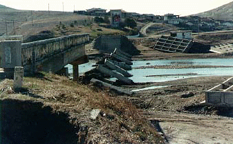
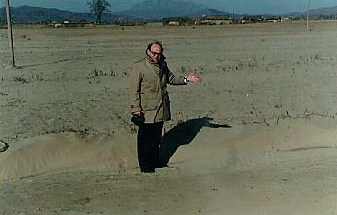
The Communist government says summer floods
have left a half-million people homeless, washed away schools,
crops and livelihoods in three-quarters of the country and cost 68 lives.
(Kevin Sullivan - Washington Post - 22 September 1995)


Here are excerpts from the
Preliminary Findings of United Nations Assessment Mission,
Department of Humanitarian Affairs, 12 September 1995:

Following three episodes of exceptionally heavy rainfall during the
periods of 7 to 15 July, 26 July to 12 August, and 17 to 20 August 1995,
the Government of DPR Korea reported that 145 counties and cities
in eight provinces, or 75% of the country, had been affected by the floods.
The Government estimated that 5.2 million people had been affected
out of whom approximately 500,000 or 100,000 families,
had lost their homes and been displaced.
The floods had also caused severe damage to agricultural land and
production, critical facilities such as hospitals and health center,
water supply and other infrastructure such as roads, bridges, and
irrigation system as well as to industrial facilities.
Although it was initially believed that no lives had been lost,
later the Government reported 60 to 70 casualties
with more people missing and feared drowned.
The Government estimates that the total cost of the damage
caused by the floods to exceed 15 billion US dollars.

In response to a request from the Government of DPR Korea,

ON 29 AUGUST 1995,

a four-person United Nations Disaster Assessment and Coordination
Team was dispatched by the United Nations
...
[S]evere damage to agriculture, property and infrastructure had occurred.
All of this has been in riverine valleys and on flood plains,
the predominant geographic features of the affected areas.
Up to 6 September, no damage to areas outside of this kind of topography
(metropolitan areas) had been seen.
In the riverine areas, damage was typical of flash flooding,
in which some structures were severely damages and
crops and livestock swept away.
In some places, agricultural fields had been covered
with several layers of sand and gravel.
Small and medium scale irrigation and water storage systems had
frequently been completely destroyed.
In the floodplain areas, water had covered crops for long periods
so that maize and other crops had been submerged,
and rice grain had rotted. ...
Official figures indicate that
a total of 96,348 houses have been damaged. ...
In the worst circumstances where dams had burst or
flash flooding had occurred, entire houses and
their contents have been washed away.
In other areas houses have been submerged and some contents salvaged.
...
The weather has remained warm since the period of the floods
but is now beginning to cool into autumn.
During the winter, from November through March,
it will be extremely cold.
Average temperatures during January, the coldest month,
vary between minus 5 degrees Celsius and minus 20 degrees Celsius.
MORE THAN 200 INDIVIDUALS PERISHED IN THE BLIZZARD OF '93. MANY LOST THEIR LIVES IN THE FLORIDA TORNADO OUTBREAK ASSOCIATED WITH THE STORM. [note by TS - Cuba suffered major storm damage.][Much of the above and following is from the 1994 Weather Guide Calendar with Phenomenal Weather Events, (1993 - The Weather Channel - -article by Declan Cannon and Tom Moore).] BLIZZARD: A severe winter storm associated with low temperatures, strong winds of at least 35 mph, and limited visibility due to heavy or blowing snow. The word blizzard first surfaced in the American frontier in the early 1800s, to describe a shot blast from a rifle. First appearing in the Estherville Northern Vindicator in 1870 in reference to a raging snowstorm that passed through Iowa, the word quickly caught on to describe a significant winter storm event. By 1888, the word blizzard had officially found its way into metereological vernacular! "... The Blizzard of '93 is about to commence ... All preparations should have been made ... I wonder what the forecaster who sat here 105 years ago today [was thinking]." As Warren Snyder, Senior Forecaster for the National Weather Service Office in Albany, New York typed these words in his early morning state forecast discussion on March 13, 1993, an intense winter storm was spawning tornadoes in Florida, and bringing heavy snow to the southern United States. For two days, this intense, quick moving storm would continue to pummel the eastern United States with blizzard conditions and gusty, even hurricane-force winds. Before the storm was over on March 14, the media would dub this blizzard, "the Storm of the Century", and many meteorologists would compare, as did Warren Snyder, the Blizzard of '93 with the notorious Great Blizzard of 1888. STORMTRACKS - March 12 - March 14, 1993: MARCH 12: Storm system rapidly intensifies in the Gulf of Mexico, with 60-70 mph winds. With temperatures near freezing, snow spreads rapidly northward from southern Mississippi through northwest Alabama, central an eastern Tennessee, southwest Virginia and southern West Virginia. Cold rain falls in most of Georgia through the western Carolinas. Toward midnight, heavy thunderstorms with wind gusts over 70 mph move from the Gulf coast into Florida. Over 50 tornadoes are produced. Off the southwest coast of Florida, the Dry Tortugas experience a wind gust over 100 mph. MARCH 13: By midnight, cold rain changes to snow as far south as Mobile, Alabama. Heavy snow begins to fall in northwest Georgia, and in mountains of Tennessee, North Carolina and western Virginia. Snow commences in Washington, D.C., Baltimore, Philadelphia and New York City. By 7:00 a.m., intense area of low pressure is located over south central Georgia, producing 20-30mph winds and gusts to 40 mph. Meanwhile, winds off the west coast of Florida turn west. Storm surge rises to over twelve feet in counties north of Tampa. Some residents are forced to climb up to rooftops to avoid drowning. Heavy snow falls in Atlanta and up through the Appalachian Mountains. Light snow begins to fall in the southern tier of New York state. The snow tapers off to flurries in the South by early afternoon. Warmer air moves in from the Atlantic Ocean causing snow to mix with rain in the Washington, D.C. and Baltimore. The Appalachian Mountain region, however, remains under a blizzard warning. Coastal areas from the Carolinas to New England experience wind gusts 60-90 mph. Snow falls in New England by early afternoon. During the afternoon hours, the storm continues to intensify, setting numerous low barometric pressure records from North Carolina to Massachusetts. These records indicate that the Blizzard of 1993 was more intense storm than that of 1888. Snow turns to rain in New York City, Long Island and southern New England. Blizzard conditions continue in western Pennsylvania, central New York state, and northern New England. The rapid movement of the storm spares the middle Atlantic states from additional coastal flooding. MARCH 14: By morning, the storm system center has moved into Maine. Snow begins to taper off in Pennsylvania and New York state. Isolated pockets of heavy snow continue to occur in Syracuse, New York, aided by moisture from Lake Ontario. Storm Totals: Blizzard of 1993: SNOW Mt. Mitchell, NC 52" Syracuse, NY 43" High Knob, VA 40" Halcott Center, NY 40" Latrobe, PA 36" Albany, NY 27" Pittsburgh, PA 24" Beckley, WV 31" Kancanagus, NH 28" Chattanooga, TN 20" Wilmington, DE 14" Birmingham, AL 13" New York City, NY 11" WIND GUST Dry Tortugas 109 mph Flattop Mountain, NC 101 mph Peconic (Long Island), NY 93 mph Key West of Lake Okeechobee, FL 74 mph New York City (LaGuardia), NY 68 mph LOW PRESSURE RECORDS Newark, NJ 28.42" Wilmington, DE 28.44" Richmond, VA 28.51" Augusta, GA 28.94" Thunder, Lightning...& Snow ? On Saturday morning, March 13, 1993, many people in the Eastern United States woke up to the sounds of gusting winds and crashing thunder. Mystified by what they heard, they ran to their windows to see flashes of light amidst heavy, blowing snow. Thunder and lightning at the height of a blizzard? How could this happen? Although it is an unusual occurrence, thunderstorms can accompany a snowstorm. This weather phenomenon is known as thundersnow . Moderate to heavy snow falls when warm, rising moist air overrides cold air close to the earth's surface. Most snowstorms do not produce thunder and lightning because the dynamics in the atmosphere are not unstable enough to create this interesting phenomenon. Virtually all weather occurs in the lowest level of the atmosphere called the troposphere. Significant decreases in temperature in the upper levels of the troposphere create unstable air. An extremely powerful winter storm system, if accompanied by intensely cold air in the upper regions of the troposphere, can produce thundersnow. Although thundersnow is an uncomon event in most of the eastern United States, it does accompany lake effect snow in the Great Lakes region. Meteorologists refer to this winter weather event as "thunder lake effect". Because of their height and close proximity to cold air in the atmosphere, locations in the Rocky Mountains also experience thundersnow, particularly during the spring and fall months of the year. The Appalachian Mountains rarely experience thundersnow as they lack the great heights of the Rockies. The Storm of the Century released more snow, hail, rain and sleet than any other storm since 1888. - Life magazine, week of 13 Sep 93 The day the lightning broke all records THE BLIZZARD of 1993, which wreaked havoc along the eastern seaboard of the US in March, didn't just set records for snowfall and low pressure. It also produced an unusually large number of lightning flashes - up to [5000] an hour. Richard Orville, of Texas A & M University, has studied this blizzard lightning (Geophysical Research Letters , vol 20, p 1367), examining data from a network of magnetic direction finders. These devices recorded the characteristics of lightning flashes from cloud to ground across the US. Each of the flashes recorded in Orville's survey was reported by at least two direction finders within 600 kilometers of the flash. At this range, the detectors can distinguish between flashes carrying negative charge downwards, which accounts for most of them, and those carrying positive charge downwards which produce the remaining 13 per cent. The storm developed over Texas and the Gulf of Mexico on 12 March, then moved over Florida and up America's east coast. It set records for snowfall in places such as Birmingham, Alabama, where 33 centimeters fell, and Cooperstown, New York, which had 71 centimeters. There was most lightning near Florida, probably because of the warmth of the waters of the Gulf Stream. Overall, the storm produced 59 000 cloud-to-ground flashes, with a peak of 5100 flashes an hour and a maximum density of strikes of 0.16 per square kilometer just south of Tampa, Florida. The previous highest hourly flash rate published was 3300, though Orville says he knows of unpublished observations of 9100 an hour. But he adds: "The reasons for the high flash rates [and] the apparent rapid cessation of cloud-to-ground lightning as the storm propagated north of hte Carolinas is still to be determined." - New Scientist 11 September 1993 [ In paragraph 1, the text says 55 000, but I think it should probably be 5000. ] [ 33 centimeters is 13 inches. 71 centimeters is 28 inches. ]
Two weeks after the blizzard, on 28 March 1993, Supernova 1993J in M81 was observed on Earth, 11 million light-years away..
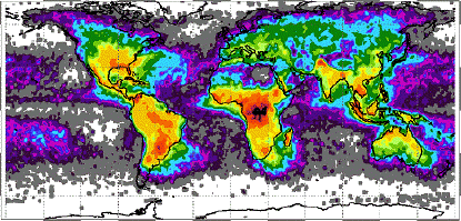
... For reasons not fully understood, positive electric charge accumulates on smaller particles -- that is, on hydrometeors smaller than about 100 micrometers -- while negative charges grow on the larger ones. Winds and gravity separate the charged hydrometeors and produce an enormous electrical potential within the storm. ... where does lightning strike most frequently? Central Africa. "There you get thunderstorms all year 'round," ... says ... Hugh Christian, project leader for the National Space Science and Technology Center's (NSSTC's) lightning team at NASA's Marshall Space Flight Center ... "[It's a result of] weather patterns, air flow from the Atlantic Ocean, and enhancement by mountainous areas."...".
and have blue jets at altitudes from 10 to 30 miles,
red sprites at altitudes from 30 to 60 miles,
and circular elves at altitudes from 60 to 70 miles,
as illustrated and described in the July 1997 issue of Discover magazine:
that shows lightning below the blue jets.
According to the Drudge Report for 10 July 2001, on 6 July 2001 a tornado "...
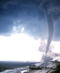
which caused more than $8 million in damage, was captured by brave Paul Donovan from his [ Myrtle Beach, South Carolina ] hotel balcony. The summer scare formed over the ocean as a waterspout and moved ashore into this busy beach resort's business district, injuring several people, destroying mobile homes and overturning buses. ...".
On 3 April 1974, during the 1974 Super Outbreak of Tornadoes, a radar-determined cloud top of 68,000 feet was observed.
the largest number of tornadoes ever produced by one storm system. Thirty of these tornadoes were classified as F4 or F5 on the Fujita-Pearson Scale. Before the fourteen state rampage was finished, over 300 people had lost their lives in 48 killer tornadoes. On the morning of April 3, an area of low pressure was located in central Kansas. A warm front extended east-northeastward through the lower Ohio River Valley. South of this front, extremely unstable air had gathered during the overnight hours and was rapidly spreading north. A cold front stretched from the area of low pressure south through Texas. At the upper levels of the atmosphere, a powerful trough was spreading strong winds aloft over much of the eastern half of the country. With the warm air in place and a cold front approaching, along with favorable upper air dynamics, intense thunderstorms developed rapidly in the afternoon of April 3. Those thunderstorms spawned nearly 150 tornadoes across parts of the Midwest, Ohio and Tennessee River Valleys and Southern states from the afternoon of the 3rd into the early morning hours of the 4th. An astonishing six F5 tornadoes were spawned. An F5 tornado hit Guin, Alabama, destroying the entire town and killing 20. Fortunately for Huntsville, Alabama, the tornado lifted back into clouds just before reaching the city limits. Nearly 30 people perished in Brandenburg, Kentucky when another F5 tornado touched down, leaving the town in ruins. Over 300 homes were destroyed and over 2,100 were damaged by an F5 in Xenia, Ohio, which killed 34.
Could the 1998 Tornado outbreak be related to the 1997-1998 El Nino?
1974 was not an El Nino year. Could the 1974 Super Outbreak have been related to human attempts to modify and control storms?
According to the American Meteorological Society:
The Spring 1997 Newsletter on Atmospheric Electricty, of the AMS, AGU, and ICAE discusses subjects including cloud seeding, electrostatic, and electromagnetic phenomena. See also the Fall 1997 Newsletter, the Spring 1998 Newsletter , the ICAE '99 Homepage, and the Atmospheric Electricity Homepage.
According to the Proceedings of the 1997 Test Technology Symposium of the U. S. Army Test and Evaluation Command (TECOM), a major subordinate command of the U.S. Army Materiel Command (AMC):
Some people say that things such as HAARP might be used for weather modification.
According to a 12 August 2000 article by Robert Mathews in the New Scientist, "... Ben Eastlund ... an expert on electromagnetism ... thought, why don't we create a missile shield in the ionosphere using microwave antennas powered by natural gas generators? By firing microwaves at the ionosphere ... you can generate a huge cloud of energetic electrons, corralled by the Earth's magnetic field. As the ballistic missiles fell through this cloud, the electrons would set off the chemical explosives in the missiles, detonating their nuclear warheads before they could do any harm. ... Eastlund's idea. ... demand[ed] a huge array of antennas 20 kilometres across, capable of zapping the ionosphere with a million megawatts of microwave power ... Eastlund ... saw that with so much power, it might be possible to heat the edge of the jet stream of high-speed winds that passes right over Alaska, altering its direction. ... experiments in the late 1960s suggested that you could weaken hurricanes significantly by using silver iodide to trigger rainfall at the expense of vicious winds. ... Eastlund's new proposal for weather modification: using microwaves to choke off killer tornadoes. Courtesy of ... non-linear effects, Eastlund found he could make do with a lot less power to quash tornadoes than he had initially envisaged ... The basic idea is that a network of satellites equipped with vast solar panels, tens of kilometres across, collect the Sun's light and convert it into microwaves ... an SPS with relatively small solar panels--a few kilometres across, say--could produce a billion watts or so ... the University of Oklahoma ... Center for Analysis and Prediction of Storms (CAPS) ... simulation showed that a blast of microwaves from an SPS might indeed choke off tornado formation. ... kilometre-sized SPS would ... hit the downdraft with a tightly focused beam of microwaves with a frequency between 10 and 100 gigahertz--a frequency range absorbed by water vapour and raindrops--and pack a punch of about a billion watts. ... the power density would be around 1 watt per square centimetre, which isn't all that different from what you get inside a microwave oven ... As for high-flying planes getting between the storm and the beam, the SPS radar would detect these and switch the beam off until the plane had passed. Unfortunately, ... birds are ... being fried ... People are 70 to 80 per cent water ... You need ... [to] ... be able to control the beam so that it doesn't hurt people ...".
According to a 13 February 2002 BBC article: "... Conservationists have expressed alarm at the demise of around

... The World Wildlife Fund said the Monarchs, which died last month, were killed by a combination of cold weather and rain. Millions of butterflies make the annual flight of up to 3,000 miles from Canada or the United States to Mexico. They leave North America in the spring and arrive in the pine forest havens in Michoacan, west of Mexico City in October or November. Their arrival coincides with Mexico's Day of the Dead celebrations. Many villagers believe the butterflies represent the spirits of their ancestors. ... deforestation may have exacerbated the cold snap's effect on the butterflies by reducing the forest canopy which helps to regulate temperature. ...".
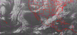
Here is a GOES infrared satellite image of 2345Z 12 Jan 2002 from Unisys:
According to a 12 February 2002 New York Times article by Carol Kaesuk Yoon: "... After a severe winter storm in mid-January, in the mountains of central Mexico, dead monarch butterflies lay in piles on the ground, in some places more than a foot high. Between 220 and 270 million frozen butterflies had rained down from roosts where they normally festooned towering trees, researchers estimated. "It was really macabre," said Dr. Lincoln P. Brower, a butterfly biologist. "I've been going down there for 25 years, and I've never seen anything like it." Most of the monarchs in the two biggest colonies in Mexico were killed in the storm, in the largest known die-off ever of these butterflies, according to a report by Dr. Brower and a team of researchers from Mexico and the United States. ... 74 percent of the monarchs at the Sierra Chincua colony and 80 percent at the Rosario colony had been killed. Along with a few smaller colonies, which scientists have not surveyed, the butterflies in these major colonies make up the entire breeding stock of monarchs for the eastern United States and Canada. ... The Rosario and Sierra Chincua colonies are thought to harbor perhaps two-thirds of all the butterflies in Mexico's monarch sanctuaries, which are in mountains in the state of Michoac·n, west of Mexico City. ... the species as a whole was not in danger because other, smaller populations of monarchs that did not migrate to Mexico could be found elsewhere, such as in the western United States. ... According to the report, the storm on Jan. 12 and 13 dropped about four inches of rain in the area and was followed by freezing temperatures, a deadly combination as monarchs are known to be particularly susceptible to freezing if they become wet. ... the thinning of the forests in the relatively small area they have chosen for their habitats could threaten the butterflies by increasing their exposure to these elements. ... an earlier study showed that in the last 30 years, nearly half the prime forest in the area had been degraded or destroyed. ... the number of acres covered by monarchs and counts of monarch-filled trees are thought to provide reliable estimates of colony size. So researchers compared the size of the area covered by monarchs and the numbers of trees, both before and after the storm, to determine the reduction in colony sizes. "This is the lowest known number of butterflies at these sites over the last 27 years, " Dr. Taylor observed. ... Dr. Brower said he feared that the numbers, if anything, were an underestimate of the actual death toll, as researchers only counted the butterflies on the ground. He said he had just received word from researchers in Mexico that the storm had left monarchs dead everywhere, including at their roosts in the trees. "Some of these clusters hanging on the trees are just all dead," he said. "It's terrible." ...".
...