Rank     Hurricane          Year   Category   Damage in billions
 1.    SE Fla.,Alabama      1926      4          $72.303
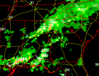
Bill was born on 29 June 2003 in the Gulf of Mexico, made landfall on the Louisiana coast, and came near Cartersville on 1 July 2003, bringing about 4 inches of rain, but not much wind. Bill was very asymmetrical - its East half brought a lot of moisture up from the Gulf of Mexico, but its West half brought dry air down from the continental USA. That Wet East / Dry West structure made Bill
a Yin-Yang  Storm.
Even as Bill moved on toward the Chesapeake Bay, it left a string of clouds and rain
stretching back through Valdosta, Georgia (where my mother Billie Ham Smith grew up), and along the Gulf Coast. They persisted around Valdosta for the 4th of July 2003
and then came up to Cartersville on 5 July 2003.
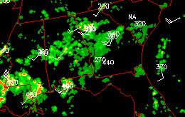
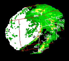
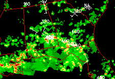
Images of Bill were taken from images on the Unisys weather web site: radar on 2315Z 1 July 03, infrared on 1415Z 2 July 03, radar on 1715Z 4 July 03, and radar on 1615Z 5 July 03.
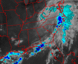
Kenna was born on 22 October 2002 in the Pacific Ocean off the coast of Mexico, and grew to be a category 5 hurricane on 24 October 2002, according to the Unisys weather web site, which also contained this 0715Z 25 OCT 02 enhanced infrared satellite image
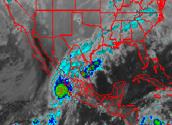
and the 1845Z 28 OCT 02 radar image shown below.
According to a 27 October 2002 article by Tim Weiner in The New York Times: "... a powerful Pacific hurricane ... called Kenna ... which passed 180 miles from a meeting of world leaders ... in Cabo San Lucas on the Baja peninsula, was the third most powerful storm ever recorded to strike Mexico from the Pacific ...".
After crossing Mexico, Kenna was less organized but its remains continued eastward and northward, producing wind and over an inch of rain in Cartersville on 28 October 2002.
Floyd itself did not come to Cartersville, but many refugees did come to Cartersville from coastal Georgia, Florida, and South Carolina after an evacuation of two million people that, according to the BBC, "... "President Clinton has described ... as "the largest peace-time evacuation in our history". ...".
According to the BBC, the evacuation followed a 15 September 1999 declaration by President Clinton of a federal state of emergency in Florida and Georgia.
The BBC said, 16 September 1999: "... One of the strongest hurricanes ever recorded in the Atlantic has battered the Bahamas ... When it hit the Bahamas ... Floyd was classed a category four hurricane, and was close to being in the strongest category five. ...".
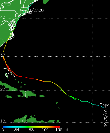
Floyd did not hit Florida, Georgia, or South Carolina, but did hit the USA coast in North Carolina, and proceeded up the coast,
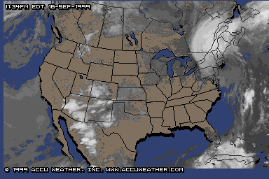
with the eye hitting Hamden, Connecticut, around 11:30 PM EDT on 16 September 1999.
According to the Drudge Report of 25 September 1999:
The viscous soup of floodwater, sewage, hog waste, animal and human carcasses, chemicals, gasoline, fertilizer, pesticides and other pollutants churns in Roseboro, N.C -- more than a week after Hurricane Floyd passed through. "Floyd has created a public health threat unprecedented in the region," reports Sunday's PHILADELPHIA INQUIRER, "and any day now, on the surface of this 18,000-square-mile cesspool, billions of mosquitoes will begin to hatch." The paper's Richard Lezin Jones reports: "At week's end, epidemiologists, health and environmental officials were expressing concern about the possibility of an outbreak of gastrointestinal and other diseases, such as pathogenic e. coli, caused by contaminated drinking water." ... ".
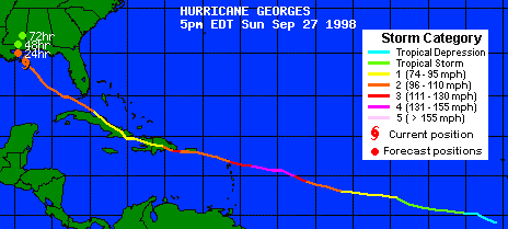
Georges killed at over 370 people (see AP reports on 29 Sep 1998).
Georges began off Africa about 13 September 1998, then crossed the Atlantic Ocean and went to:
- ANGUILLA: Minor damage, temporary power outages.
-ST. KITTS AND NEVIS: Three dead, 3,000 homeless. 85 percent of homes damaged. Damage estimated at $402 million. Hospitals, police stations, schools damaged. Severe damage to airport terminal, control tower.
-ANTIGUA: Two dead, roofs ripped off hundreds of homes and businesses, main marinas damaged. Flooding along south coast towns. Hurricane caused island-wide power outage.
-GUADELOUPE: Flooding in northern towns, moderate damage to homes.
-BRITISH VIRGIN ISLANDS: Flooding temporarily closed some roads, temporary power outages.
-U.S. VIRGIN ISLANDS: Several injured, moderate damage to homes, some hotels, shops, schools on St. Croix. Widespread crop damage.
-PUERTO RICO: At least three killed directly by the storm, nine others by heart attacks and other health complications, 28,000 people in shelters. More than 17,000 left homeless. Damage at least $2 billion.
-DOMINICAN REPUBLIC: At least 210 people reported dead, dozens missing. About 100,000 homeless. Seventy percent of bridges damaged, 90 percent of banana and other plantations destroyed. Damages estimated at over $1 billion.
-HAITI: 147 deaths reported. Many missing. Flooding in Port-au-Prince, Artibonite Valley, northern coast around Cap-Haitien. Dozens of homes destroyed.
-CUBA: Five deaths, thousands of homes damaged. Nearly 20,000 homes flooded in Holguin province. Damage to coffee, cacao and banana crops. 200,000 people evacuated.
-FLORIDA KEYS: Major damage to 320 homes, including 75 houseboats. One death.
-LOUISIANA: Most of state saw wind 40 mph or less. About 14,000 took shelter in the Superdome. A tidal surge topped a levee in Florissant, east of New Orleans, letting loose 8 to 9 feet of water. Outages left as many as 260,000 without power. Two deaths.
-ALABAMA: Flash flood watches, gusts up to 85 mph. 25-foot waves clipped off fishing piers on the Gulf. Mandatory evacuations of two coastal counties. 177,000 customers without power at peak, 4,675 in shelters. No deaths or major injuries.
-FLORIDA PANHANDLE: 20 inches of rain recorded. 200 rescued from flooded homes. Interstate 10 washed out near Alabama line. As many as 82,000 without power. 225,000 evacuated. On Florida Keys, major damage to 320 homes, including 75 houseboats. One death.
Sometimes I think that storms such as Georges are alive. Georges seemed to go directly where it wanted to go, from Africa across the Atlantic toward Islands including Anguilla.
As Anguilla Local News said, then "... Georges was a Category 4 hurricane with sustained winds of 150 MPH, and was predicted by some to go on to the highest Category, 5 (catastrophic), [so the] people [of Anguilla] put in an extra effort. ... Then everyone in Anguilla and all of the friends of Anguilla said a special prayer. They couldn't ask for Georges to go elsewhere, since that would be calling down evil on neighboring islands, but they could pray for it to lose strength. And it did. As Georges neared the islands, it came up against a weather pattern that caused it to disorganize; it lost its well-defined eye, top winds dropped steadily from 150 to 135 to 125 to 115 MPH. ..."
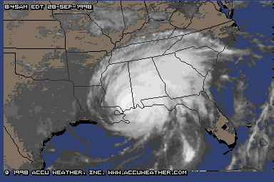
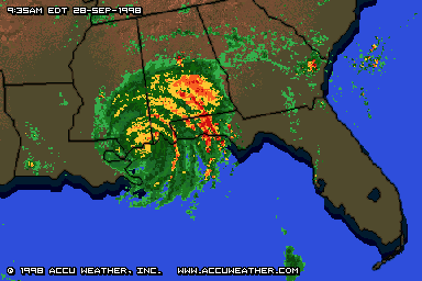
Georges was curious about the Island land masses, so it went from Island to Island from Anguilla to the Florida Keys. Then Georges realized that even though it had given up some of its strength, it was still damaging the land it was visiting. Remorseful, it decided that even though it wanted to see New Orleans, it did not want to damage the City Below (6 feet) the Sea (level), so it went East to Mississippi. Georges didn't want to die, so it kept trying to stay mostly over the Gulf of Mexico, but Georges got weaker and was pulled North and East, more and more over land, eventually coming to Georgia to die.
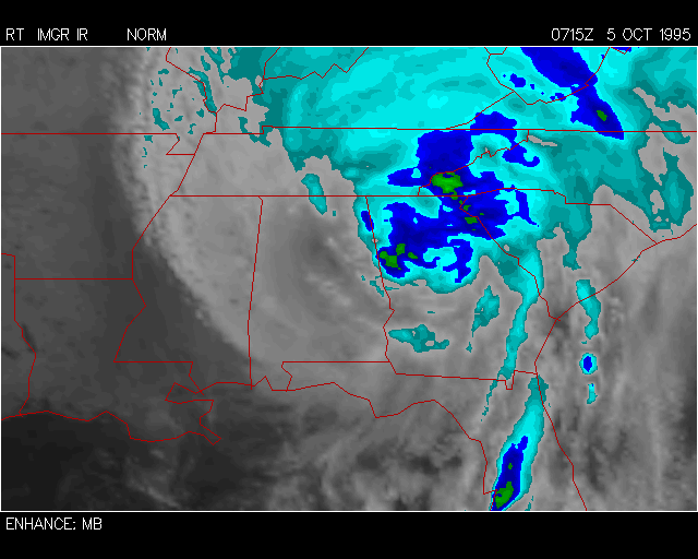
Hurricane OPAL (27 SEP-05 OCT)
Storm Max - Max Winds: 130 Min Pres: 916 Category: 4
Opal formed as a tropical depression over the Yucatan Peninsula of Mexico. Initially forecasted to move due north and not intensify, it decided to move west into the open gulf waters which allowed it to organize before its turn to the north. Moving over very warm central gulf waters, it rapidly intensified from a minimal category 1 to a strong category 4 in 12 hours. This was aided by strong thunderstorm activity near the center of the system. Opal never formed a clear cut eye which denotes most strong hurricanes. Moving over cooler waters as it neared the coast of Florida it quickly weakened to a category 3 before hitting land just southeast of Pensacola FL. This was the second hurricane to hit Pensacola this season (Erin being the other). This storm produced heavy flooding rains over Mexico and over the southeastern US.
Type           Category     Pressure   Winds   Color
Depression                   -----      < 35   Green
Tropical Storm               -----     35- 64  Yellow
Hurricane         1           > 980    65- 83  Red
Hurricane         2          965-980   84- 95  Light Red
Hurricane         3          945-965   96-113  Magenta
Hurricane         4          920-945  114-134  Light Magenta
Hurricane         5           < 920     > 134  White
Although it was not a hurricane, a thunderstorm on 1 September 2000 ( the day after a Kolar proton decay paper appeared on xxx.lanl.gov as hep-ex/0008074 ) brought over 4 inches of rain to Cartersville,.
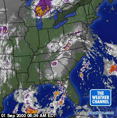
It was part of a weather pattern that looked somewhat like Hurricane Floyd, but did not have enough strong winds to be classified as a hurricane.
......