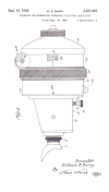
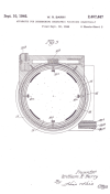
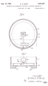
The Barry Sextant
No one uses a sextant anymore. A sextant is a navigational instrument that when leveled with the horizon can be focused on a star and used to compute a location on the Earth. Separately the Chinese, Egyptians, Babylonians, Greeks and later the Arabs discovered that they could determine their position on Earth relative to the stars. These observations gave birth to celestial navigation. Simply stated, ones position on earth could be ascertained relative to a star (fixed point) by measuring the angle of elevation (altitude) of the star from the observer (apex) and the earth (horizon). John Fremont, the famous American explorer, used a sextant with a mercury artificial horizon to determine his position during his expedition of the 1842 to map the Oregon Trail.The creation of Inertial Guidance (INS) and Satellite Navigation (GPS) have led to the demise of the sextant, but for 500 years, if you wanted to cross the ocean you needed one to find your way.
In the 1920's and 1930's aviation was booming. Lindbergh had crossed the Atlantic using a navigation method called dead reckoning.that is flying a constant heading and attempting to stay on course by correcting for winds. By the very nature of its name you can see the problems with it. Airplanes were bigger, faster and flying longer distances.
As the late 1930's approached war was raging in Europe and China. The oceans, thru size and distance, helped protect us from foreign attack, but also caused problems because we needed to traverse those distances. This was especially dangerous for airplanes flying at night and outside the range of ground based navigation aids. Winds between 8000 and 20,000 ft of altitude, where most long distance aircraft would fly, could often reach 100 knots and could blow an aircraft far off course.
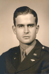
Enter William Barry
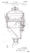
As a navigator in the Army Air Corps, he saw the problem with flying over the ocean at night and created an airplane sextant. Sextants had been on ships for centuries with their first use dating back to the mid 1400's but airplanes had a special set of problems. Night time and clouds cover the horizon and an aircraft might be traveling at several hundred miles an hour. William Barry found a way to create and artificial horizon inside his instrument. This allowed him to focus on the celestial points required and to establish his position. The war brought rapids advances in technology and by 1942 the Bendix Corporation was awarded a one million dollar contract to supply 2400 sextants for the Army Air Corps. These included a trigger that when squeezed made a series small pencil marks below the index knob. These series of "shots" could be averaged and account for the speed of the plane. Although crude by today's standards, the Army boasted that with this instrument a plane could fly the ocean and at the end of his trip be within 15 miles of his destination point. By contrast, a modern GPS will achieve an error of only 7 feet.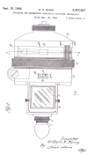
We have the original Barry prototype at the Lowndes County Museum.