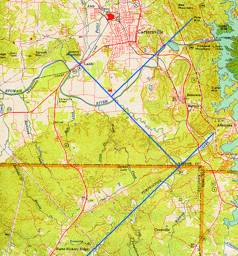
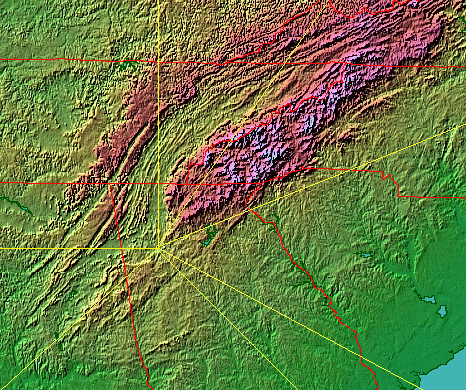
The Etowah Mounds are located just North of the Etowah River, across from Pumpkinvine Creek, at the intersection of of the blue line from Ladds Mountain and the blue line from Pine Mountain:
According to Coosa: The Rise and Fall of a Southeastern Mississippian Chiefdom (University Press of Florida 2000), by Marvin T. Smith of Valdosta State University:
"... In this volume I use the name Coosa in three senses: ... the town of Coosa .. ; ... the prehistoric and sixteenth-century chiefdom of Coosa, which was limited to the Coosawattee River Valley ... ; ... and ... the Paramount Chiefdom of Coosa ...... an alliance of several chiefdoms from eastern Tennessee to central Alabama ... Coosa apparently began ...[around]... A.D. 900 ... as a small simple chiefdom ... in northern Georgia. ... by the sixteenth century it encompassed settlements in much of ...
... the upper Tennessee and Coosa River drainages ... Following european contact, the people of Coosa fragmented and declined as European disease took its toll. ... They ... eventually became a part of the Creek Confederacy of the eighteenth century. ...
... The principal Creek deity was the Master of Breath, ... closely related to the Sun. The earthly representative of the Master of Breath was the sacred fire, kept burning in the rotunda or square ground. ... It was a special fire constructed of four logs in a cross shape ... This fire was ... never allowed to go out during the year. At ... the Green Corn Ceremony ... the principal ceremony of the year ... in the summer or early fall, when the new crop was ready to harvest ... the sacred fire was extinguished and a new fire built ... The moon ...[and]... thunder ...[were]... important [deities] ... The Creeks viewed the world as a large squre island surrounded by water, with a solid dome of sky over all. ... Above the sky dome was the Upper World ...[which]... epitomized order and regularity ... Below the island world and the waters was the Under World, which epitomized fertility, disorder, and change. It was also the home of ... supernatural ... Snake[s] ... There was also a spirit realm ... Those who had followed an upright life traveled along the Milky Way to the land of the blessed ... the Creeks had a belief in a race of little people ... The ballgame was treated much as war; there were many rituals to achieve purity before the game, including the taking of black drink ... a ritually purifying emetic beverage brewed from the leaves of the Ilex vomitoria holly. Black drink contained caffeine and was served before any important deliberation by the council. ...
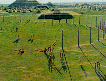
... Etowah was a large concern as early as ... A.D. 1000-1100 ... The Etowah site ... was the main power center ... ca. 1200-1350 ... At its height Etowah had six mounds. The village area covered ... 52 acres .. and was surrounded by a fortification wall with towers and a large ditch 9 meters wide and 3 meters deep ... Mound A is 18 meters high, Mound B is 10.5 meters high, and Mound C is 7.5 meters high. A large plaza, measuring 100 meters on a side and paved with clay 50 centimeters thick, lies adjacent to Mound A and Mound B. Three smaller mounds ... lie to the east of the plaza. ... Etowah likely controlled sources of copper in the fourteenth century ... In its heyday, Etowah was certainly the dominant site in the Ridge and Valley Province. ...
... after Etowah lost its power around A.D. 1350-1375 The Coosawattee chiefdom began its ascent to power. ... The Little Egypt site ...[ is on the Coosawattee River, south Fort Mountain, which drains into the Holly Creek tributary of the Conasauga River ]... The Little Egypt site ... consists of two or perhaps three mounds ... the two largest mounds ...[being]... more than 2.5 meters high ... was founded during ... the Little Egypt phase, A.D. 1350-1475. During this phase, at least four construction stages were completed on [Little Egypt] Mound A ... During the Barnett phase, A.D. 1475-1575, the village continued to grow and the second (and perhaps a third) mound was constructed. ... The Little Egypt site ... seems to ...[have remained]... the capital ...
... the [Etowah] site may have been abandoned from ca. 1350 to 1500, and then reoccupied during the sixteenth century. ...
... When de Soto arrived in the Ridge and Valley Province in northeastern Tennessee in 1540 ...
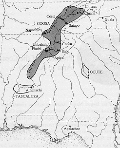
... he immediately heard of Coosa. Indeed, he had first become aware of Coosa months earlier when he was in the Provice of Ocute on the Oconee River in Piedmont eastern Georgia. ...[de Soto].. traveled ... to the town of Tali ... up the Little Tennessee River ... From ...[there he]... traveled south, perhaps along the Tellico River, following the edge of the Ridge and Valley along the ecotone with the Blue Ridge (that is, the Great Indian Warpath of the eighteenth century). ... they came to ... Little Egypt ... the Cacique (chief) of Coca (Coosa) ... was surrounded by many attendants playing upon flutes and singing ... De Soto took the Coosa chief hostage and chained up many of his people to serve as burden bearers ... [de Soto went to]... Ytaua (also spelled Itaba), probably ... Etowah ...[which was]... subject to Coosa ...[and, by then,]... little more than a minor ... village ...[de Soto then went to]... Ulibahali ... near ... Rome, Georgia, ...[and then to]... Talisi, located near ... Childersburg [or perhaps Tallassee], Alabama, ...[which was]... the last town subject to Coosa ... At Talisi, an emissary from the next paramont chief, Tasculuca, visited de Soto ...
...[In]... 1560 ... Tristan de Luna returned to the Southeast in a colonizing venture ...
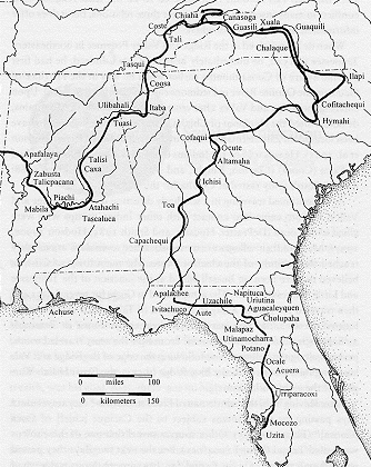
... He brought Mexican Indians and Spaniards completely equipped to establish a permanent colony. The expedition was one of the largest and best supplied of any effort in the New World. ... The colonists landed in Pensacola Bay ... a hurricane struck ... the colonists moved into the interior of Alabama ... reaching ... Nanipacana ... on the Alabama River in Wilcox County. ... They ...[searched]... for ... Coosa ..[and]... reached the province of Taxcaluca (Tascaluca) near ... Montgomery, Alabama ...[and]... Caxiti ...[on the Coosa River, and, tend days later]... Onachiqui, ... the first town of Coosa ... the expedition continued to Ulibahali ... it is likely that the Sauz detachment followed the Oostanaula River upstream to Coosa ... The arrival of the [de Soto] Spaniards in former years had driven the Indians into the forests, where they preferred to live among the wild beasts who did no harm to them ... Luna's colony soon collapsed, and the survivors returned to Mexico ...[departing from]... Mobile, Alabama ...".
According to Aboriginal Population Movements in the Postcontact Southeast, by Marvin T. Smith of Valdosta State University, printed in The Transformation of the Southeastern Indians 1540-1760, ed. by Robbie Ethridge and Charles Hudson (University Press of Mississippi 2002):
"... We have excellent archaeological data on prehistoric peoples of eastern Tennessee, northwestern Georgia, and eastern Alabama. Historical research on the expeditions of Hernando de Soto, Tristan de Luna, and Juan Pardo enables us to identify these archaeological remains as the paramount chiefdom of Coosa. However, this brief illumination by historical information quickly fades into the dark age of the seventeenth century ... These people do not reenter history until the last quarter of the seventeenth century. ... [During the] period 1675-1700 ...[the]... Cherokee probably ...[began]... moving into the Tennessee Valley. ... the Cherokee gradually moved into northern Georgia during the eighteenth century. ...".
Mounds at Moundville (near Tuscaloosa, Alabama) and at Cahokia (near Collinsville, Illinois) were also built during the Mississippian Temple Mound Building Period from about 900 A.D. to about 1575 A.D.
According to Robert Silverberg (The Mound Builders, Ohio University Press 1970, pages 259-264), "... the Missippians [Mound Builders] ... seem already to have been declining when the Spaniards came [around 1540]. ... the Temple Mound folk of the Southeast [slid] into a less ambitious way of life. Huge mounds were no longer built. ... around the old mounds the familiar festivals and rituals continued, but hollowly, until their meaning was forgotten and the villagers no longer knew that it was their own great-great-grandfathers who had built the mounds. ... All of these Indians of the Temple Mound region had only faint and foggy notions of their own history ...... The leaders of ... a loose confederation of tribes in Georgia and Alabama, numbering some 30,000 Indians in 50 good-sized towns ... called themselves the Muskhogee, but English traders, meeting a branch of this tribe near a creek, called them the Creek Indians ... Other tribes [Chickasaw and Choctaw] in the same general part of the country spoke related Muskhogean languages ... it seems likely that the Creeks ... were direct descendants of the Temple Mound people, [but] nothing in Creek myth confirms that idea. ... The Creek Indians ... appear to have forgotten their ancestry, though they recalled the ancient customs to some extent. ...
... Only one group of Southeastern Indians still maintained a real link to its Temple Mound heritage ... the Natchez, a Muskhogean tribe living in seven small villages east of the present city of Natchez, Mississippi. We know a great deal about these people, largely due to the writings of ... [Europeans of the French Colony of Louisiana, such as Antoine Le Page du Pratz from Holland and the French Jesuit, Jesuit Pierre Charlevoix] ... The Natchez rebelled against the French in 1729. ... they were all but wiped out; the survivors became scattered among other Southeastern tribes, who looked upon them as gifted with mystic powers. ...
... To the north of these Muskhogean-speaking peoples lived the Cherokees, whose language was Iroquoian,
[As noted by David B. Kelley, the first words of the US Constitution, We the People, are a direct translation from the Iroquois constitution.],indicating that they had come from the west and north ... European explorers ... found the Cherokees in command of a vast region along the Tennessee Valley. [The Cherokees] were at constant war with their neighbors, particularly the Creek Indians to the south and the Chickasaws to the west. ... the Cherokees ... had come as invaders from another region. ... The Cherokees themselves ... looked upon the mounds as the work of an earlier people. ..."
According to the Cahokia website, around March 1998, "During the process of installing horizontal drains to relieve the internal water in Monks Mound that had contributed to several severe slumping episodes along the west side (Second Terrace), the drilling rig encountered stones about 140 feet in and 40 feet below the surface of the Second Terrace. The operator said it felt like "soft stone," probably limestone or sandstone, and that it was mostly cobbles or slabs at least six inches in diameter. The drill went through about 32 feet of stones and the drill bit broke off. We have no idea what it is, what shape or size it is, or why it is there. It should not be there. No other cores or excavations have revealed stone in Monks Mound or any other mound at the site, or, as far as we know, at other Mississippian mound sites. We do not know its vertical thickness or the extent of it horizontally, other than the 32 feet that the drill went through."
Monks Mound at Cahokia is the largest Mississippian Mound (100 feet high, 1,037 feet long, and 790 feet wide) with a volume of 21,976,000 cubic feet. The second largest Mississippian Mound is Etowah Mound A (60 feet high) with a volume of 4,300,000 cubic feet.
The Missippian Temple Mound sites were organized much like those of the more advanced Central Americans, such as the Maya (300 AD - 900 AD) and their succesors.
They also resemble mounds in China near Xi'an, such as the Qin tomb (about 200 BC)
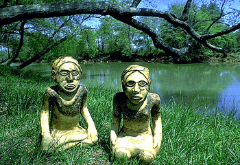
Marble Female and Male images, about 2 feet high, found by Lewis H. Larson, Jr., in his excavation of Mound C for the Georgia Historical Commision in the 1950s:
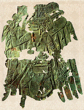
Copper Plate 20 inches long found beneath the skull of a skeleton in a stone-lined grave in Mound C during an excavation by the Bureau of American Ethnology in 1885:
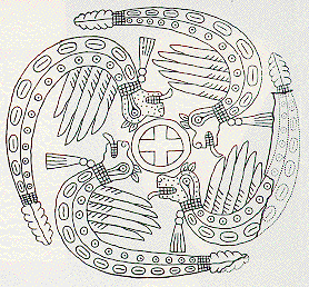
Shell Gorgets found with burials in Mound C: Upper - diameter about 4 3/4 inches, found by W. K. Moorehead escavation in the 1920s for the Phillips Academy; Lower - diameter about 2 5/8 inches, found by W. K. Moorehead escavation in the 1920s for the Phillips Academy; Left - Spider and Sun Circles, diameter about 2 inches; and Right - Turkeys, diameter about 1 5/8 inches:

The symbols on these Gorgets are similar to symbols fournd at other Mississippian sites, such as:
Spiro, Oklahoma, shell (9 inches by 6 1/2 inches):
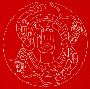
Moundville, Alabama, ceremonial disk (diameter 12.5 inches):
Cahokia, Illinois, Woodhenge Structures for marking Solstices and Equinoxes:
According to a web page on the web site for America's Mysterious Furnaces:
"... In the late 1920's Warren King Morehead excavated Indian mounds in northern Georgia at the Etowah Mound Group and at Carter's Quarter. The archaeologist found iron artifacts in the Carter's Quarter mound ...".
Carter's Quarter is North of the Etowah Mounds, about 2/3 of the way to Fort Mountain, and the mound site there is also sometimes referred to as Little Egypt.
The book Exploration of the Etowah Site in Georgia, ed. by Warren King Moorehead, University Press of Florida 2000, states at pages 153-154, about the Carters Quarter Site:
"... Our little collection of iron implements was sent to the Metropolitan Museum of Art, New York, where each specimen was examined by an official familiar with arms and armor. In his opinion, as to whether they were Spanish swords, he was cautious, but stated that they were old, and not of American Colonial period. ... There were no hilts or maker's marks ... we have referred to hard burnt floors in both Mound C and in Etowah village. Mr. Carter's mound was not large, yet within it we discovered a burnt area deeper, or thicker, than was found elsewhere during our explorations in the South save, possibly, one of the mounds near Natchez. This began some 20 inches below the surface, extended downward for at least three feet .. the men had some difficulty in breaking through this mass in order to reach lower levels. Several of the skeletons were found below its outer edges, but none were beneath the heaviest burning. The purpose of this intensive burning remains unknown. It was in no sense a lodge floor or dance ground. ...".
is just across the Etowah River to the South of the Etowah Mounds. The Etowah Mounds were built where Pumpkinvine Creek flows into the Etowah River.

If you go upstream along Pumpkinvine Creek from the Etowah River, you go Easterly until you reach the area of the Pivot Point of the Cartersville Fault. If you continue upstream from there, you turn around and go SouthWesterly along a fault line roughly parallel to and SouthEasterly of the Cartersville Fault.
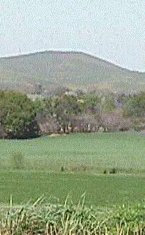
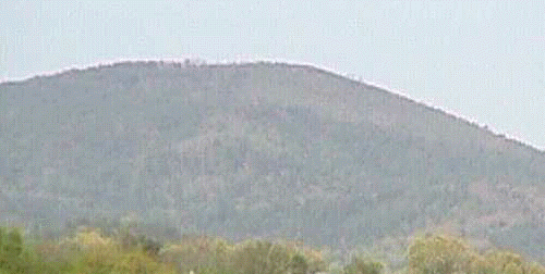
Ladds Mountain, also called Ladds Quarry Mountain because of a 20th century rock quarry, has a highest peak at elevation 1057 feet and two lower 1020 foot peaks, one to the North and one to the SouthEast of the highest peak. The highest peak, marked by the X,
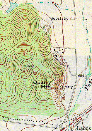
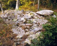
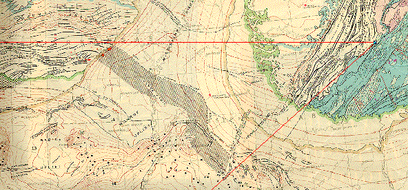
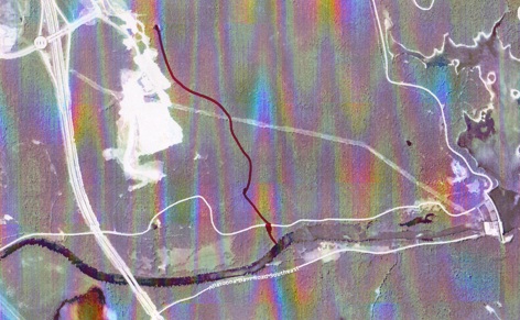
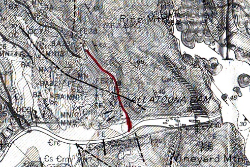
was the site of a Stone Structure that may have been contemporaneous with the Etowah Mounds. The Stone Structure were described by Whittlesey in 1883, who was quoted by Wauchope in his Memoirs published in the Archaeological Survey of Northern Georgia as saying "... It has now the appearance of a heavy stone fence which has fallen down. There are six openings ... having a breadth of 10 to 60 feet ... It is an irregular oval figure inclosing the rocky summit ... The elevation ... at the center, is 50 feet above the terrace ... where the loose stones are lying. ...". The illustration in the publication
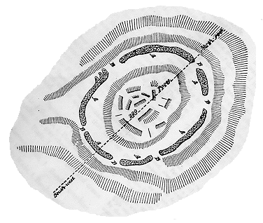
(which I have here oriented with North up, so the labelled directions North-East and South-West are oriented conventionally) seems to me to be labelled incorrectly, because if you overly it on a topo map of the area
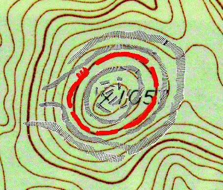
you see that, although the Stone Structure itself (shown in red) follows the 1000 foot contour closely, and is in fact 57 feet (close to 50 feet) below the summit, the lower contours are inconsistent. However, if you invert the illustration both horizontally and vertically, you get a map of the Stone Structure that not only has the Stone Structure following the 1000 foot contour even more closely, but also has the lower contours consistent with the topo map:
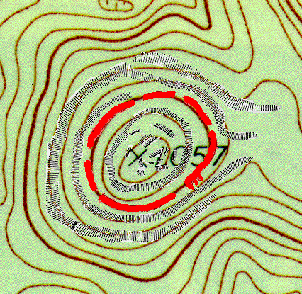
Therefore, I think that the published illustration of the Stone Structure was inadvertently inverted both horizontally and vertically in the process of printing (a fairly common mistake in printing).
.... at the top of ... Fort Mountain ...
... Locations of similar walls [include]
...[The Fort Mountain Stone Structure]... runs 855 feet and varies in height from two to six feet. When built, it was probably significantly taller. ... Who built it? When was it built? ... Local Indian culture speaks of a race of "moon-eyed" people. ... Another myth revolves around the Welsh prince Madoc. ...".
According to an Y Tylwyth Teg web page:
"... Fort Mountain derives its name from an ancient rock wall which protects the highest point of the mountain. ... The Cherokee's called the wall-builders "moon-eyed people," because they could see better at night than by day. These moon-eyed people were said to have fair skin, blonde hair and blue eyes. ... Currently, most scholars believe that the wall originated about 1100A.D. ... the Welsh prince Madoc ...[ In honor of the Welsh, I like a modification
of the Union Jack that includes the Red Dragon of Wales, along with the St. George Cross (horizontal-vertical red) of England, the St. Andrew Cross (diagonal white with blue background) of Scotland, and the St. Patrick Cross (diagonal red) of Ireland. ]
... is said to have arrived in Mobile Bay around 1170 and moved north from there. The mysterious wall is said to have been built by Welsh Explorers ... Several petroglyphs support the existence of this legend. Following is a paper which could very well explain and clarify the story. A CONSIDERATION: WAS AMERICA DISCOVERED IN 1170 by PRINCE MADOC AB OWAIN GWYNEDD OF WALES? By: Jayne Wanner ... In 1170 A.D., a certain Welsh prince, Madoc ab Owain Gwynedd, ... took his ships and headed west, seeking a better place. He returned to Wales ...[and]... convinced more than a few of his fellow countrymen ... to return to this wondrous new land ... what is now Mobile Bay, Alabama. ... The choice of Mobile Bay as Madoc's landfall and the starting point for his colonists is grounded in two main areas.
One is the logical assumption that the ocean currents would have carried him into the Gulf of Mexico. Once there and seeking a landing site, he would have been attracted to the perfect harbor offered in Mobile Bay ...
... The second ... reason, is a series of pre-Columbian forts built up the Alabama River, and the tradition handed down by the Cherokee Indians of the "White People" who built them.
Testimony includes a letter dated 1810 from Governor John Seiver of Tennessee in response to an inquiry by Major Amos Stoddard. The letter, a copy of which is on file at the Georgia Historical Commission, recounts a 1782 conversation Sevier had with then 90-year-old Oconosoto, a Cherokee, who had been the ruling chief of the Cherokee Nation for nearly sixty years. Seiver had asked the Chief about the people who had left the "fortifications" in his country. The chief told him ... that he "... had heard his grandfather and father say they were a people called Welsh, and that they had crossed the Great Water and landed first near the mouth of the Alabama River near Mobile. ..."... He called their leader "Modok." ...
[ Questions in my mind are:
On the other hand:
... Three major forts, completely unlike any known Indian structure, were constructed along the route settlers arriving at Mobile Bay would have taken up the Alabama and Coosa rivers to the Chattanooga area. Archaeologists have testified that the forts are of pre-Columbian origin, and most agree they date several hundred years before 1492. All are believed to have been built by the same group of people within the period of a single generation, and all bear striking similarities to the ancient fortifications of Wales. The first fort, erected on top of Lookout Mountain, near DeSoto Falls, Alabama, was found to be nearly identical in setting, layout, and method of construction, to Dolwyddelan Castle in Gwynedd, the birthplace of Madoc. ... The settlers would have traveled up the Alabama River and secured themselves at the Lookout Mountain site, which took months, maybe even years to complete. It is presumed the hostility of the Indians forced them to move on up the Coosa River, where[, along the Etowah River was the Ladds Mountain Stone Structure, along the Oostanaula/Conasauga River was Rocky Face Mountain, and, along the Oostanaula/Conasauga/Holly Creek, was] ... Fort Mountain, Georgia. Situated atop a 3,000 foot mountain, this structure had a main defensive wall 855 feet long, and appears to be more hastily constructed than the previous fort. Having retreated from Fort Mountain, the settlers then built a series of minor fortifications in the Chatanooga area, before moving north to the forks of the Duck River (near what is now Manchester, Tennessee), and their final fortress, Old Stone Fort. Formed by high bluffs and twenty-foot walls of stone, Old Stone Fort's fifty acres was also protected by a moat twelve hundred feet long. ... The trail of the settlers becomes more speculative with the desertion of Old Stone Fort. Chief Oconostota, in relating his tribal history, tells of the war that had existed for years between the White people who had built the forts and the Cherokee. Eventually a treaty was reached in which the Whites agreed to leave the area and never return. According to Oconostota, the Whites followed the Tennessee River down to the Ohio, up the Ohio to the Missouri, then up the Missouri ". . .for a great distance. . .but they are no more White people; they are now all become Indians...." ... by the early eighteenth century very few traces of their Welsh ancestry remained. Although several tribes have been considered as possible descendants of the Welsh settlers, the most likely is the Mandan tribe, who once inhabited villages along tributaries of the Missouri River. These Mandan villages were visited in 1738 by a French explorer, The Sieur de la Verendrye, and he kept a detailed journal describing the people and their villages. At the time of Verendrye's visit, the tribe numbered about 15,000 and occupied eight permanent villages. The Mandan chief told him that the tribe's ancestors had formerly lived much farther south but had been driven north and west by their enemies. Verendrye described the Mandans as "white men with forts, towns and permanent villages laid out in streets and squares." ... Like so many other Indian tribes, they did not survive the smallpox epidemic introduced to them by traders in 1837. Now considered extinct, the Mandans do however, lay claim to the distinction of being the only Indian tribe never to have been at war with the United States. ...".
According to a Madoc web page: "... When asked "If MADOC had gone to America, what type of ship would have been used?". Professor Gwyn Alf Williams replied "A Viking ship with a shed on it". ...

... The Vikings had been the dominant seafaring nation along the western seaboard of Europe for several hundred years. ...". According to another Madoc web page: "...
 and wrote prolifically about them. He compared their canoes to
Welsh coracles ...
and wrote prolifically about them. He compared their canoes to
Welsh coracles ...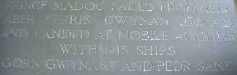 Marking Madoc's sailing from Aber-Kerrig Gwynan
(Rhôs-on-Sea) Gwynedd N Wales ...".
Marking Madoc's sailing from Aber-Kerrig Gwynan
(Rhôs-on-Sea) Gwynedd N Wales ...". According to a Bibliomania web page: "... Wales is also called Gallia, Galis, and Gaul, especially in mediæval romance: hence, Amadis of Gaul is not Amadis of France, but Amadis of Wales ..".
According to a Data Wales web page: "... The Celts of Gaul (roughly modern day France) settled in Britain in the centuries after 600 BC. By the time that Gaul and Britain were brought into the Roman Empire (most of Britain was conquered by 85 AD) these lands shared a language which linguists call Gallo-Brittonic. This was an Indo-European language, just one of nine different branches. From Gallo Brittonic descended Welsh, Cornish and Breton, the so-called P Celtic languages. (The Indo-European kw sound had developed into p). The Celtic spoken in Ireland and the Isle of Man became known as Q Celtic (the kw sound had been retained and was written first as q and later as c). The Brittonic language survived Roman rule in Britain but the Anglo Saxon invasions which followed the departure of the Roman garrisons around 400 AD led to the language being largely supplanted by Old English. Wales is the only part of Britain where a version of the old Brittonic language has survived. The language developed over the ages becoming Welsh in the period between 400 and 700 AD. ...".
Acccording to a Pagan Religion of the Anglo-Saxons web page: "... Of the gods of the early English we only know of three: Tir, Woden and Thunor (the Tyr, Odin and Thor of Viking mythology ... Thunor was also popular amongst warriors, and of all the English gods was the closest to his Scandinavian counterpart. Although his symbol of the hammer was used in England, his commonest symbol was the fylfot [an Old English word] cross (the swastika of modern times), which seems to have also symbolised both the sun and a shield. ...".
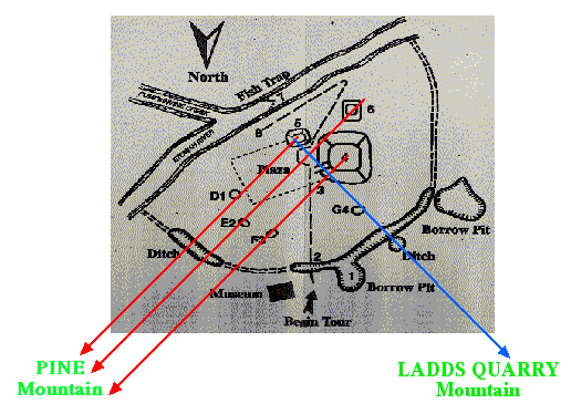
On the Ladds Mountain Stone Structure, there are 6 Openings around the Stone Structure and 3 Prongs at the SouthEast Opening.
You see along the 3 yellow lines shown on the topo map:
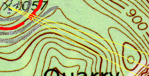
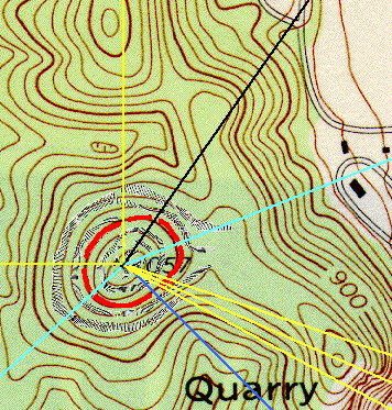


David Archer, who provided me with copies of parts of the Memoirs of Wauchope, told me that the stone structure around the 1057 foot summit was destroyed many years ago when the stone was used to make gravel for roads, and the rock structure at the 1020 foot contour of the hill to the SouthEast of the summit contained a grave, with copper breastplate, ceremonial stone ax, and other artifacts.
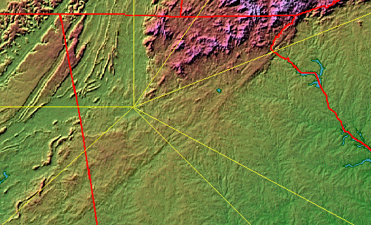
If the lines-of-sight from the Ladds Mountain Stone Structure are extended further
(map based on maps from fermi.jhuapl.edu/states/)
If the lines-of-sight from the Ladds Mountain Stone Structure are extended still further
(map based on maps from fermi.jhuapl.edu/states/)
If the Western and SouthWestern lines-of-sight from the Ladds Mountain Stone Structure are extended still further
From a global point of view

(map based on a Replogle globe)
the lines-of-sight from the Ladds Mountain Stone Structure can be thought of as lying in a plane tangent to the surface of the Earth at the top of Ladds Mountain, and passing directly over points on Earth that are on great circles lying in planes perpendicular to the tangent plane and containing the lines-of-sight:
The global point of view leads to considering what astronomical objects can be seen from the top of Ladds Mountain along each line-of-sight. The latitude of Ladds Mountain is about 34 degrees 10 minutes North, and:
Since, from the Etowah Mounds, Ladds Mountain is 90 degrees West of Pine Mountain, and Pine Mountain is about due NorthEast (45 degrees North of East) from the Etowah Mounds:
is on the Cartersville Fault, just North of the Etowah River at Allatoona Dam. According to A Preliminary Report on a part of the Iron Ores of Georgia - Polk, Bartow, and Floyd Counties, by S. W. McCallie, Geological Survey of Georgia Bulletin No. 10-A (1900):
"... The Hurricane Hollow Ore-Banks ... owned by the Etowah Company, is located on the foot-hills of Pine Mountain ... The most extensive workings ... was done before the Civil War ... to obtain ore for the Cooper Furnace ... on the Etowah River ... the Big ore-bank is ... on lot 465, near the end of a steep ridge, which extends down from Pine Mountain. ... Stalactitic ore
[Stalactitic Ore is formed by mineralized solutions dripping from the ceilings of Caves.]
also frequently occurs; but it is limited in quantity. ... Immediately below the excavations on the hillside, are two old tunnels ... manganese ... is often found in this vicinity, associated with the iron deposits. The brown ore at the Big ore-bank frequently has a reddish color, and seems to be partly altered to hematite ... On the eastern side of the ridge ... are numerous other excavations ... cut after cut and tunnel after tunnel ...".
The Caves in which the Stalactitic Ore was formed may be analogous to Caves which:
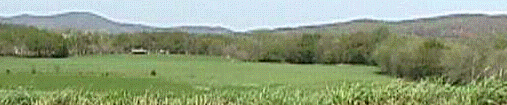
Here is a topographic view (of Pine Mountain looking toward the SouthWest (the direction of the Etowah Mounds) from the NorthEast:

According to an 18 October 2002 article by Lisa R. Schoolcraft in the Atlanta Business Chronicle: "... The Hinds family in Maine, which owned the land, commonly called the Etowah Mining and Manufacturing Co. property, plans to donate nearby 230 acres to the city of Cartersville for use as a nature park with trails, said Tony Smith, an attorney representing most of the sellers. The park will include Pine Mountain, he said. "The property was originally assembled in the 1830s for mining," Smith said. "It was the iron works that Sherman destroyed on the way to Atlanta. Mining dwindled away in the 1960s and we've just had the property. ...". I also donated my relatively small interest in the Pine Mountain property. Of the 6 individuals and 4 trusts making up the Hinds ownership in the Pine Montain property, all arranged to participate in the donation except for one individual and her trust, but those interests were even smaller than mine. It is ironic that a Hinds family ancestor fought in the Union army, was captured, and died in the horrible conditions of the Andersonville POW camp in southwest Georgia. Thus Pine Mountain, on which Mark Anthony Cooper flew the first disunion flag of the Southern Confederacy, was donated as a public park by a Union family.
Here is a closer view from the top of Mound A:
Here is a wider view from the top of Mound A:
Here are some lines-of-sight from Mounds A(4), B(5) and C(6) to Pine Mountain and Ladds Mountain.
The Etowah Mounds are about 34 degrees North latitude.
Pine Mountain is about due NorthEast (45 degrees North of East) from the Etowah Mounds, and so is substantially North of the Summer Solstice Sun and Winter Solstice Full Moon (about 27 degrees North of East), which, as seen from the Etowah Mounds, rise over Allatoona Dam on the Etowah River.
Three interesting things now rise over Pine Mountain as seen from the Etowah Mounds:
Since, from the Etowah Mounds, Ladds Mountain is 90 degrees West of Pine Mountain, and Pine Mountain is about due NorthEast (45 degrees North of East) from the Etowah Mounds:
References:
Exploration of the Etowah Site in Georgia, ed. by Warren King Moorehead, University Press of Florida 2000.
The Mound Builders, by Robert Silverberg, Ohio University Press 1970.
The Southeastern Indians, by Charles Hudson, University of Tennessee Press 1976.
Lost Civilizations: Mound Builders and Cliff Dwellers, Time-Life Books 1992.
Sun Circles and Human Hands, edited by Emma Lila Funderburk and Mary Douglass Funderburk Foreman, American Bicentennial Museum, Fairhope, Alabama, 1957.
Memoirs of Wauchope (quoting Whittlesey (1883), published in the Archaeological Survey of Northern Georgia. David Archer gave me copies of parts of these Memoirs, and told me that Wauchope wrote the Memoirs during the Depression 1930s as part of a WPA project, and that the Memoirs were published in the 1960s.
Maps from fermi.jhuapl.edu/states/ website.
Map at top of page, and 3D Relief Topo map of Pine Mountain, from DeLorme Topo USA on DVD-ROM (3D Vertical Exaggeration 2x).
USGS Maps, including: Cartersville Quadrangle (1:24,000); Greater Atl;anta Region (1:100,000); (1974); Rome, Atlanta, Athens, and Greenville (1:250,000).
Tectonic Map of the United States (exclusive of Alaska and Hawaii), by the United States Geological Survey and the American Association of Petroleum Geologists (1962).
Here are more references, including some references about maps.
......
According to Archaeological Survey of Northern Georgia with a Test of Some Cultural Hypotheses, Memoirs of the Society for American Archaeology, Number 21, Salt Lake City 1966, by Robert Wauchope:
"... the Cartersville area, we shall assign site designations to some remains recorded by Cyrus Thomas in the Twelfth Bureau of American Ethnology Annual Report. ...
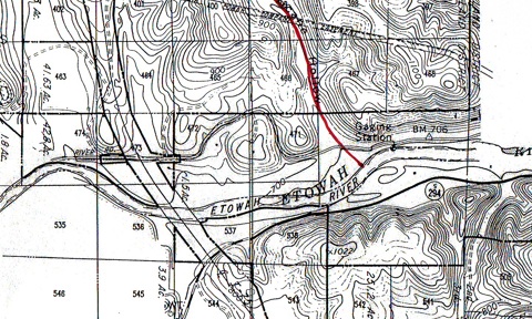
Fig. 172. Bartow and Cobb County sites: Rowland Mounds (Br-44) ... Sams Farm (Br-45) (sic), McCaskey Creek (Br-20) ...[red line indicates Hurricane Hollow Creek]...

...
Br-44 (Rowland Mounds)
South bank of Etowah River about 3 miles southeast of Cartersville, says Thomas (1894: 313).
The group consists of three mounds and a cemetery; the largest is somewhat irregular in form, the longer diameter 150 feet, the shorter 140, the whole height 20 feet, but the height of the artificial portion, 15 feet, rounded on the top. One-half of this was dug away, but finding neither specimens nor skeletons, no further investigations were made.
The excavations, as reported by Thomas, revealed eight strata: soil 6 in., yellow clay mixed with samd 3 ft. 6 in., sand and ashes 1 ft., sand 2 ft., ashes 1 ft., yellow clay 3 ft., sand and ashes 1 ft., uniform level of red clay 3 ft., naatural elevation 5 ft. high.
From the above data, it appears that the Indians at the Rowland site built a clay platform 3 feet high and occupied it until sand and ashes acccumulated to a depth of 1 foot; then they enlarged the platform another 3 feet and another foot of ashes and debris accumulated. This process was repeated until there were three and possibly four superimposed structures, each capped with an accumulation of ashes. Perhaps the superstructures burned down in each case. The 2-foot deposit of sand near the center of the mound may represent a river overflow.
Thomas writes of the cemetery east of the mound near the riverbank:
At one point were three skeletons lying extended side by side on their backs, heads cast. They lay at a depth of 2 1/2 feet under the surface, and rested on a single layer of water-worn bowlders which formed the bottom of the grave. The stones had the appearance of hving been heated and then dipped into cold water. At the head of the grave ws a medium-sized bowl. Resting on the faces was an iron boring implement and hammer; around the neck of the middle skeleton were the remains of a strand of small shell beads. Between the skeletons were found a broken soapstone pipe, a piece of mica, and fragments of pottery.At another point was a single skeleton, doubled up and resting on the left side. This was 2 feet below the surface, resting on a layer of stone similar to those in the other grave.
Br-46 (sic) (Sams Farm)
Cyrus Thomas (loc. cit.) describes three other mounds, "not far distant, on the farm of Mr. Lewis Sams."
No. 1, circular in form and round on top, circumference of base 152 feet, and height 5 feet, was found to be simply a mass of yellow sand with shells mixed through it. Part of a human upper jaw was found, but ghis was probably accidentally put in while building, as there were no indications of burial. At the bottom in the center was a bed of charcoal 6 inches deep and 2feet in diameter.No. 2, circular and flat on top, circumference of the base, 142 feet; diameter of the top, 12 feet; height, 3 feet. Built entirely of sand, without stratification, but with shells intermixed, no ashes, coals, relics, or remains in it.
No. 3, circular, and round on top; circumference of base, 111 feet, height, 3 feet; composed entirely of sand.
Br-20 (McKaskey Creek)
Series of lithic stations and possibly a village site along a half-mile stretch of the north (right) bank of the Etowah River, less than half a mile upriver from the mouth of McKaskey Creed ((Fig. 172). The main occupation seems to have been preceramic. ...".
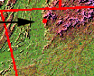
In the images below, from Google Earth, Cartersville Mineral District Map by Kessler, a topo map, and Google Earth, red indicates Hurricane Hollow Creek:
Here is a more complete image of Robert Wauchope's Fig. 172:
.